
Fondoform.........................................................................................................................................................................................................................Fondoforme
Fundoforma / Fondoforma / Fondoform (Geometrie) / Fondoform(几何) / Фондоформа (часть донной формы рельефа) / Fondoforma (geometria) /
A more or less horizontal sedimentary interval deposited in an subaquatic or aquatic environment (under whatever water-depth), downstream of a dipping seaward interval that is coeval and genetically associated with it.
See: « Basin (sedimentary) »
&
« Turbidity Current »
&
« Accommodation »
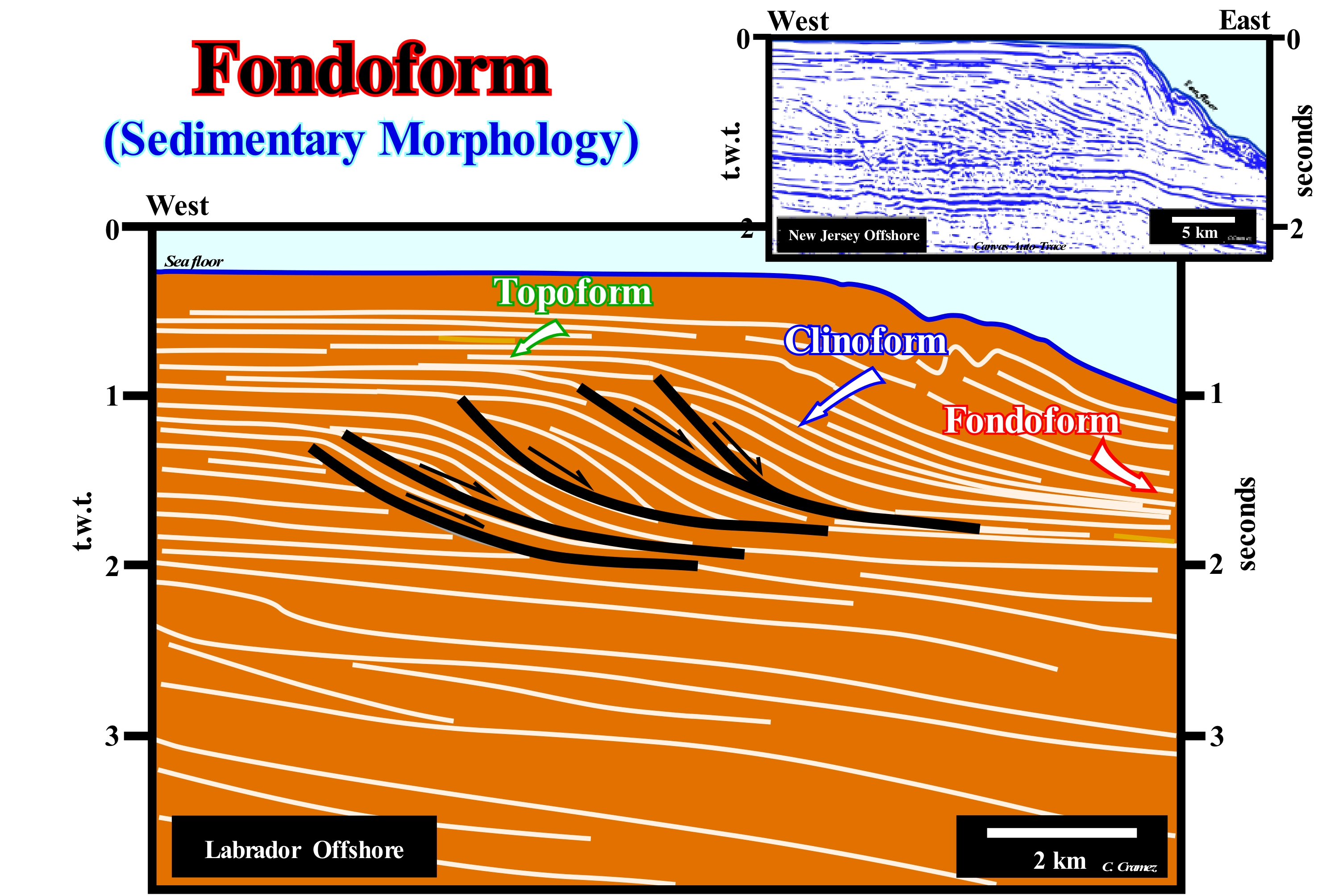
Canada offshore and, in particular, the Labrador offshore corresponds to the stacking of several types of basins of the classification of the sedimentary basins of Bally and Snelson (1980). On regional seismic lines, it is easy to recognize from the bottom to top: (i) A Basement consisting, in general, Precambrian supracrustal rocks ; (ii) A Paleozoic flattened folded belt ; (iii) Mesozoic rift-ype basins, formed in response to the lengthening of the Proto-Pangea supercontinent and (iv) An Atlantic-type divergent margin developed during the Mesozoic / Cenozoic. The break-up of the supercontinent, which emphasizes the end of the lengthening of the lithosphere and, consequently, the end of normal faulting system responsible for the rift-type basins formation (half-grabens filled, basically, by non-marine sediments) is accompanied by an implementation of lava flows. On seismic lines, these flows induce seaward dipping reflectors (SDRs). The lava flows thicken toward the sub-aerial expansion centres, fossilizing the most distal rift-type basins (closest to the break-up zone). It is the commencement of the oceanic expansion, which, of course, begins as sub-aerial, before becoming oceanic (oceanic crust formation). On this tentative geological interpretation of a Canvas auto-trace of a detail of a seismic line this offshore, the sub-horizontal reflectors of the upper interval forming the Late Miocene abyssal plain (continental slope about 600-800 m thick) can be considered as fondoforms. The same is observed in the auto-trace of a detail of a seismic line shot in the eastern offshore of the USA (Baltimore canyon). These sub-horizontal reflectors at the base of the progradations, associated to the continental slope, are the natural downstream continuation of the clinoforms that mark the continental slope, which in turn, are the downstream continuation of the topoforms. Fondoforms, clinoforms and topoforms underline the three main sectors forming a depositional surface : (i) Coastal Plain and Platform (upper sub-horizontal reflectors) ; (ii) Continental slope (reflectors dipping seaward) and (iii) Abyssal plain (lower sub-horizontal reflectors). It can be said the lateral and synchronous association of topoform, clinoform and fundoform constitutes a chronostratigraphic line, that is, a depositional surface. On this tentative geological interpretation of Labrador offshore seismic line, some of the fondoforms are associated with landslides along normal faults induced by the instabilities of the upper slope or the continental edge. They are associated with turbiditic deposits. These landslides are corroborated by the reflector terminations (toplaps by truncation) of the lower faulted blocks (foot-walls), whose fault-planes become horizontal down-dip. The toplaps by truncation are, particularly, well visible in the oldest fault. In Labrador offshore, during the regressive phase of the post-Pangea continental encroachment cycle, most turbidite lobes (submarine fans) were, probably, deposited under highstand geological conditions (sea level higher than the basin edge). In this area, submarine floor fans (SBFF) are better explained by the model proposed by E. Mutti for turbidite depositional systems (highstand setting) than by to the model proposed by P. Vail (lowstand setting). For Emiliano Mutti, these turbidite deposits are associated with turbidity currents caused by landslides from continental edge, which carry the sediments to the abyssal plain where they settle since the currents decelerate and lose the transport capacity. In the Vail model, submarine basin floor fans (SBFF), deposited in the abyssal plain, downstream of the deep-water depositional break and connected or not with continental slope, are associated with significant relative sea level falls (unconformities). The sea level becomes lower than the basin edge. The terrigeneous influx that the water-courses lead seaward, is abandoned on the continental slope, where they trigger turbiditic currents which carry them to the lower parts of the basin. They settle down in the form of submarine basin floor fans (SBFF). Later, they are fossilized either by submarine slope fans (SSF) or by the distal sediments of lowstand prograding wedges (LPW). The erosion observed in the present-day basin edge (with platform) is due to the contour currents.
Fondothem......................................................................................................................................................................................................................Fondothème
Fundotema / Fondotema / Fondothem (Sedimentäre Intervall) / Fondothem (沉积时间间隔) / Фондотема / Fondotheme (sedimenti) /
Set of sediments associated with a fondoform.
See: « Fondoform »
&
« Progradation »
&
« Turbidite »
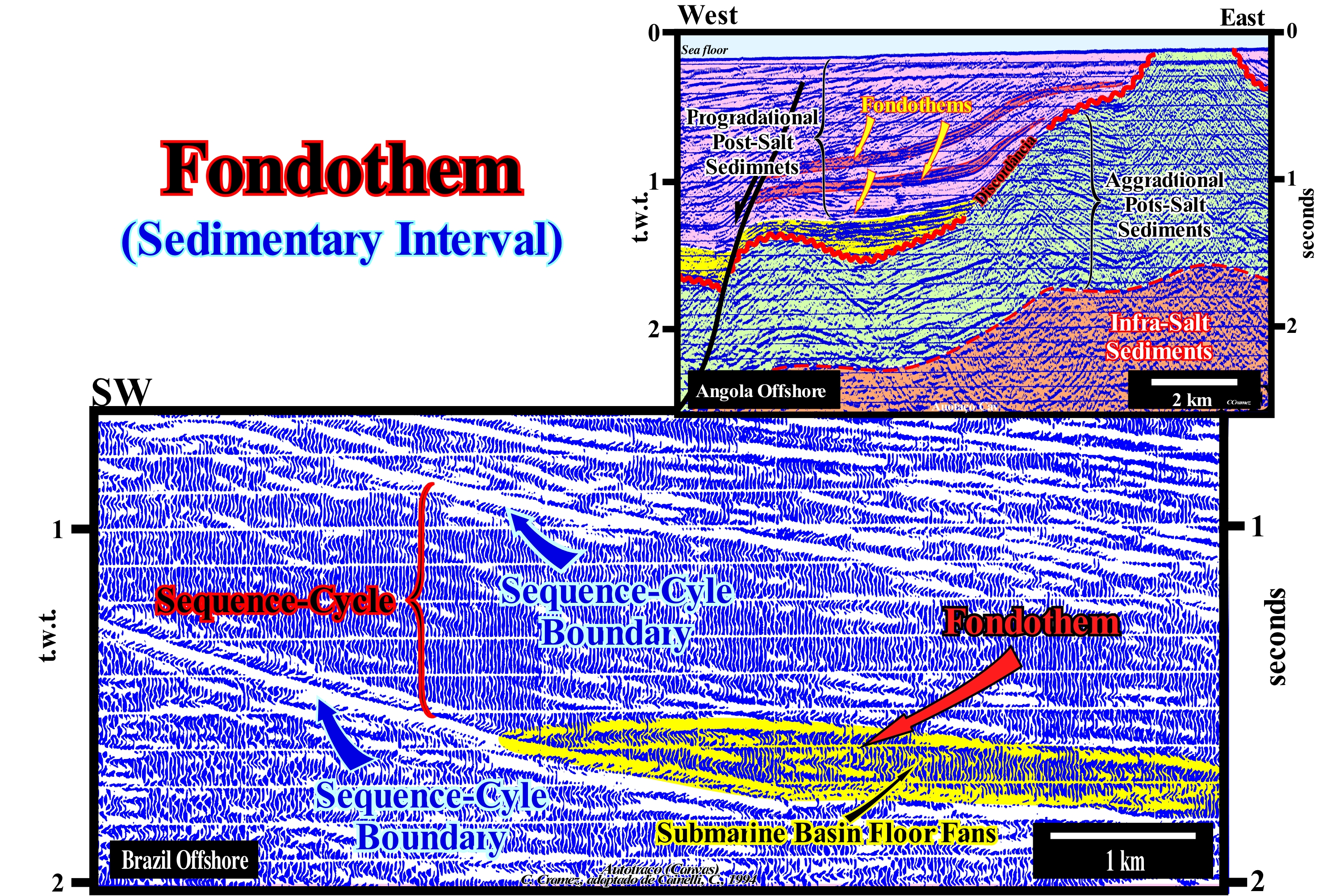
Since the advent of sequential stratigraphy (late 1970s), the terms fondoform and fondothem, which are virtually synonymous, have always been little used. At present-time, if a geoscientist says that in the detail Brazil offshore seismic line, illustrated on this figure, a fondothem is visible under certain progradations, there is, hardly, anyone who understands what he means. The same is true for the Angola offshore example, illustrated at the top of this figure. Nowadays, using the sequential stratigraphy terminology, a geoscientist says a set of turbiditic lobes, probably, submarine basin floor fans (SBFF), of the lower lowstand systems tracts subgroup, deposited at the base of the slope in association with a significant relative sea level fall* i.e. in association with an erosion surface (or its correlative paraconformity in deep-water). Later, within the considered sequence-cycle, the submarine basin floor fans (SBFF) were fossilized by the lowstand prograding wedge (LPW). Actually, the fondoforms of the upper lowstand systems tracts sub-group. Likely, these fondoforms are made up of of deep-water shales. In the preliminary tentative geological interpretation of the detail of the Brazilian offshore seismic line the middle lowstand systems tracts sub-group of a sequence cycle, i.e., the submarine slope fans of slope (SSF) is absent. On the contrary, it is perfectly seen that the fondothem is, directly, fossilized by the lowstand prograding wedge (LPW) of the sequence-cycle. The seismic interval limited between the two unconformities (or their correlative deep-water paraconformities) corresponds to the distal part(of a sequence-cycle (downstream of the last basin edge of the previous sequence-cycle) were, just, the lowstand systems tracts group is represented. The transgressive interval (TI) and the highstand prograding wedge (HPW), which form the highstand systems tracts group, if present (deposited SW of this detail). Another possibility is that the progradations deposited above the turbiditic fans (fondothems) belong to the highstand prograding wedge (HPW). In this case, the submarine slope fans (SSF) and the lowstand prograding wedge (LPW) will be absent. If such a hypothesis is not refuted by supplementary data, the turbiditic deposits (in yellow in the tentative interpretation) are perhaps better explained by the model of E. Mutti than by the model of P. Vail. The turbidite body appears to have been deposited during highstand geological conditions (sea level above the basin edge) and the turbidity currents responsible for the transport and deposition of sedimentary particles appear to have been induced by ruptures and landslides of the upper continental slope, when the basin does not have a continental shelf (lowstand geological setting) or by failures of the basin edge**, when the basin has a continental shelf (highstand geological setting). In the E. Mutti model, turbidite currents can also be triggered by river floods, either in highstand or in lowstand geologic conditions. On the tentative interpretation of Angola offshore (auto-trace), none of indicated fondothems (in the lower fondothem, coloured in yellow, the clinoforms and topoforms were not deposited) was tested by an oil exploration wells, which is surprising, knowing that an important column of heavy oil was found, in the 1980s, in the salt structure, on the right side of the auto-trace, by Cegonha well ≠ 1.
(*) Sea level, local, referenced to the base of the sediments (top of the continental crust), or to the sea floor. The curve of relative sea level changes is nothing other than the result of the combined action of absolute (eustatic) sea level (supposed global and referenced to the Earth's centre or a satellite) and tectonics (subsidence, when the predominant tectonic regime is in extensional, i.e., when the sediments are lengthened or raised, when the predominant tectonic regime is in compressional, i.e., when the sediments are shortened).
(**) Basin edge is the name given to the continental edge when the basin has a continental platform (shelf). When the basin does not have a continental platform, geoscientists call it continental border or continental edge.
Food Chain.................................................................................................................................................................................................Châine alimentaire
Cadeia Alimentar / Cadena alimenticia / Lebensmittelkette / 食物链 / Пищевая цепочка / Catena alimentare /
Representation of predator/prey relationships between species within an ecosystem or habitat.
See: « Theory of the Evolution »
&
« Autotroph (organism) »
&
« Heterotrophic (organism) »
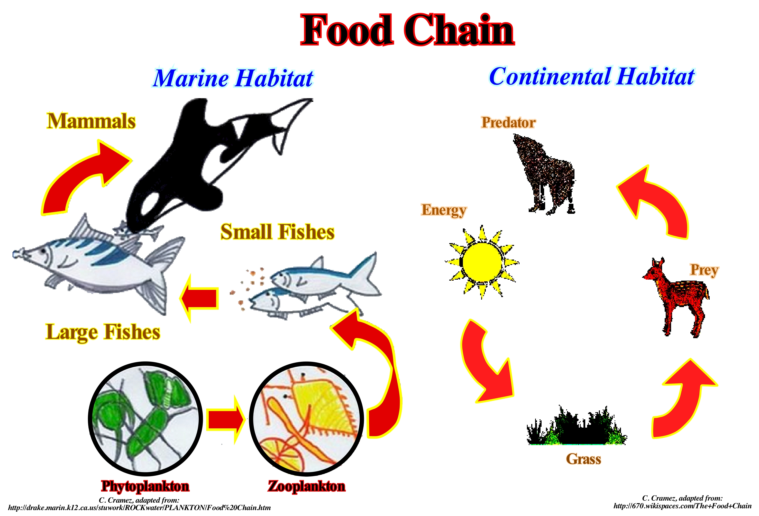
As illustrated in this figure, many food chain models may be used depending on habitat or environmental factors. Of course, all food chains are based on autotrophic organisms, i.e., organisms capable of producing their own food. In almost all food chains, solar energy is introduced into the system as light and heat, and used by autotrophs (i.e., producers) in photosynthesis. Carbon dioxide (CO2) is reduced, that is to say, it gains electrons. It is combined with water (source of hydrogen atoms) to produce glucose. This process can be represented by the following equation: 6CO2 + 12H2O + light → C6H12O6 + 6O2 + 6H2O. This equation when expressed in a simpler form: 6CO2 + 6H2O + light → C6H12O6+ 6O, conceals the fact that the atoms of the dioxygen produced do not come just from water. The decomposition of water produces hydrogen, but this reaction is not spontaneous. It requires energy from the Sun. The CO2 and OH2, both stable, are oxidized compounds of low energy. Glucose is a high energy compound and a good electron donor capable of storing solar energy. This energy is wasted by cellular processes and the development of organisms. The sugars of the plants are polymerized* and stored as carbohydrates (sugar, starch, cellulose, etc.). Glucose is also found in fats and proteins. Proteins can be manufactured from nitrates, sulfates and phosphates from soils. When an autotrophic organism is eaten by a heterotrophic, the carbohydrates, fats, and proteins of autotrophs become the energy sources of heterotrophs. In food chains, carbon dioxide is recycled through the carbon cycle, when carbohydrates, fats and proteins are burned to produce carbon dioxide and water. Oxygen released by photosynthesis is used in respiration as an electron receptor to release the stored chemical energy in organic compounds. In most food chains, the vast majority of consumers feed on several species, which in turn feed on other species. Dead organisms are consumed by detritus, predators and decomposers, such as fungi and insects, returning to the soil as nutrients.
(*) Polymerization is the chemical reaction that gives rise to the polymers, which are formed from structural units known as monomers. Petroleum hydrocarbons, for example, are examples of monomers. Hydrocarbons such as styrene (C6H5CH=CH2) and ethylene (C2H4) reacting in a chain form plastics such as polystyrene and polyethylene.
Footwall...........................................................................................................................................................................................................Bloc faillé inferieur
Bloco Falhado inferior / Bloque fallado inferior / Geringere Fehler Block /下盘, 较低的断块 / Лежачий бок / Footwall, Blocco di faglie inferiore /
Faulted-block underneath the fault plane. Synonym with Lower Faulted Block.
See: « Hangingwall »
&
« Fault »
&
« Tectonics »
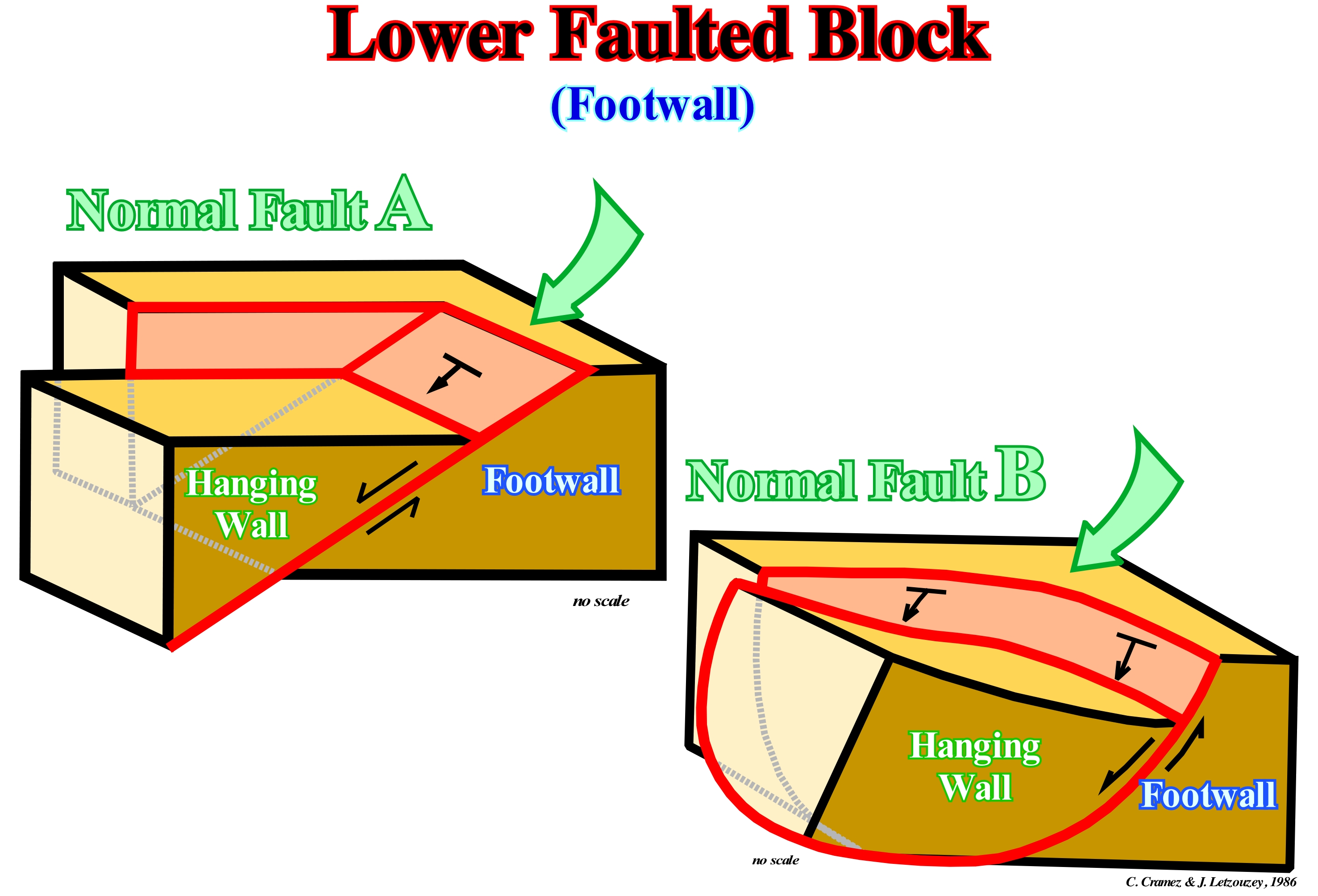
When a geoscientist walks on a fault plane, it walks on the lower faulted block, the footwall. In a normal fault, the footwall is always the block that has been relatively raised in relation to the upper faulted blocks, i.e., the hanging wall. In a reverse fault, it is the opposite, the footwall is the block, which descended relative to the hanging wall. In this sketch, the fault A, abruptly, terminates against a transfer fault, which, generally, transfers the lengthening of the sediments (extension) to another normal fault. If the plane of the fault is, in cartography, more or less, rectilinear, the lengthening of the sediments is, practically, constant along the fault trace. On contrary, as the trace of fault B is curvilinear, the sedimentary lengthening (extension) varies. It is maximum in the central part of the fault trace and minimum (zero) at the ends. A normal fault plane has, always, a dip that decreases in depth. At the macroscopic scale (scale of geological charts and seismic lines), there are no vertical normal faults. A vertical normal fault does not lengthen or shorten the sediments, i.e., it serves no purpose. On a seismic line, a fault corresponds to a rupture of the continuity of the reflectors. A fault plane, generally, is not underlined by any seismic reflector. However, there are three, mainly, exceptions : (I) When the fault zone* is filled or injected by salt ; (ii) When the fault zone is filled or injected by volcanic material and (iii) When the lithology of the two faulted blocks is different and the acoustic impedance of the blocks is very contrasted. A typical example is the case of a fault between a sedimentary interval (low acoustic impedance) and a basement (high acoustic impedance). Sediment compaction changes the initial dip (before compaction) of the fault plane. This is, particularly, true when the lithology of faulted blocks is an alternation of poor compacted sediments (such as sandstones or limestones) and sediments highly compactable like clayey sediments. The dip of the fault plane decreases in front of the footwall horizons that undergone more compaction. On a tentative geological interpretation of a seismic line, the dip changes along a fault plane give valuable indications on the lithology of the footwall.
(*) Area between the two faulted blocks, which may be, more or less, important, but always less than the seismic resolution.
Foraminifera............................................................................................................................................................................................................Foraminifère
Foraminífero / Foraminífero / Foraminiferen / 有孔蟲門 / Фораминиферы (простейшие животные организмы) / Foraminifera /
Single-celled protozoan of the order Foraminifera (subphyle Sarcomastigophora) that may have several nuclei. The foraminifera have a shell that can have a chamber (unilocular) or several (multilocular), from which extend protoplasmatic filaments (pseudopodia) used in the locomotion, fixation to the substrate and feeding.
See « Fossil »
&
« Relative Age »
&
« Benthos »
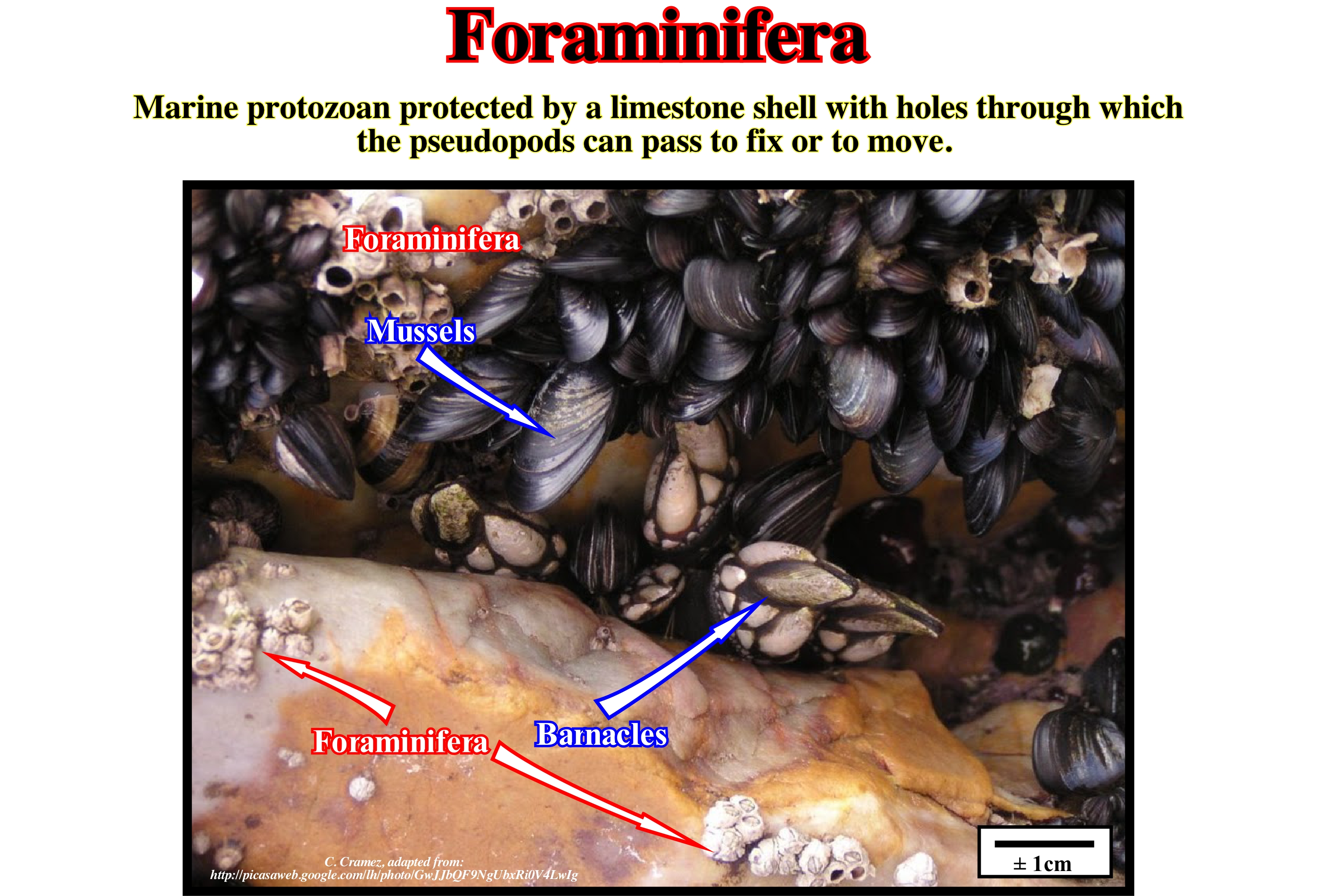
Foraminifera form a large group of protists with reticulated pseudopods (thin projections of the cytoplasm that branch out and merge into a dynamic network). All foraminifera have a teak, or shell, which may contain one or more chambers (unilocular or multilocular, respectively) and are all connected by a small aperture called a foramen. The teak may be limestone (CaCO3 in the form of calcite or aragonite), agglutinated with particles of medium or more, rarely, protein (chitin). The composition of the teak and its morphological aspects are the main elements in the taxonomic classification. Usually, they are smaller than 1 mm, but there are macro-foraminifera that reach up to 190 mm. The foraminifera are distributed from the estuary zones to the abyssal plains, and are present from pole to pole. Currently, approximately, 275,000 species are known, including fossils and live animals. The earliest fossils date back to the Precambrian. Although there is still no corroboration by the morphological correlation, molecular data strongly indicate a relation of the foraminifera with Cercozoa and Radiolaria, two groups of protists with complex teak. These three groups form the Rhizaria Kingdom. It was in the 1920s that the study of foraminifera gained great momentum when the interest of the oil industry arose. It was Joseph Cushman who first applied the knowledge on foraminifera to develop correlation techniques between strata drilled by wells. Most species are marine, although some live in brackish waters. There are freshwater foraminifera and even a species living in rainforest soils, but these represent a tiny parcel. The great majority is benthic, with only 40 planktonic morph-species. This sum may represent a fraction of the actual diversity. It is possible that morphologically indistinguishable species are genetically discrepant.
Forced Regression.....................................................................................................................................................................Régression forcée
Regressão Forçada / Regresión forzada / Erzwungene Regression / 被迫海退 / Вынужденная регрессия / Regressione forzata /
Seaward displacement of the shoreline within a sequence-cycle, when the relative sea level fall and when the position of the upper boundary of the sequence-cycle, it is difficult to locate. Since a few years ago, there has been an important debate regarding the position of the upper limit of the sequence-cycle in the transitions from marine to nonmarine environments.
See: « Relative Sea Level Fall »
&
« Sequence Boundary »
&
« Marine Regression »

Within the stratigraphic cycle said sequence-cycle, which is induced by a 3rd order eustatic cycle, whose time-duration varies between 0.5 and 3-5 My, Hunter and Tucker (1992) highlighted the importance of the architecture of coastal deposits deposited during a relative sea level fall. The relative sea level is a local sea level, referenced to any fixed point on the Earth's surface. It can be the base of the sediments (top of the continental crust) or the sea floor. The relative sea level is the result of the combined absolute (eustatic) sea level, which is supposed to be global and referenced to the Earth's centre, and tectonics. Subsidence of the sea floor, when the extensional tectonic regimes (lengthening) are predominant, or tectonic uplift when the compressional (shortening) tectonic regimes are predominant. This type of coastal deposits was, originally, taken into account in sequential stratigraphy in association with type II unconformities, such as bordering prograding wedges or descendant systems tracts. However, the difference between the type I unconformity (significant relative sea level fall, that put the sea level below the basin edge) and type II unconformity (insufficient relative sea level fall that does not put the sea level below the basin edge) is not relevant. Certain geoscientists have begun to speak in forced regressions induced by the seaward movement of the shoreline in association with a relative sea level fall. For Catuneanu (2002), forced regressions occur during the falling phases of the depositional base level. When the shoreline is forced to prograde (seaward) due to a relative sea level fall, regardless the terrigeneous influx, erosion takes place in non-marine and shallow-water environments. The water-course incisions are accompanied by the development of coastal deposits. Certain geoscientists included forced regressions in a particular sedimentary systems tract, which they called "Forced Regression Systems Wedge." The recognition of such a systems tract raises a very important question: Where should be picked the boundary of a sequence-cycle? Under or above such coastal deposits? For some geoscientists, the boundary of the sequence-cycle must be placed underneath the forced regression deposits. For others, it should be placed on top. On this problem, Miall (1977) says, theoretically, the upper limit of the sequence-cycle is, easily, recognized in non-marine environments, where it is represented by an unconformity (erosional surface). However, even in this case, it is difficult to distinguish it from other erosional surfaces, such that created by autogenic incision* of a canal, for instance. Assuming that in a forced regressive system, the problem is to find the upper limit of the sequence-cycle. It has been suggested such a limit would represent the beginning of relative sea level fall. Certain geoscientists have proposed it should be placed under the deposits formed during the falling phase. However, this solution has a problem: such a limit, which may be, locally, concordant, is truncated by the regressive surface of the marine erosion developed during the falling phase and associated with the overlying sequence-cycle (composed of an important thickness of the shoreface regressive deposits formed during the falling phase). This means the subaerial unconformity begins at the beginning of the falling phase. Erosion and incision continue until the end of the fall phase of sea level. At present, many geoscientists consider after a significant relative sea level fall that induced the unconformity that initiates a new sequence-cycle was deposited: (i) Lowstand systems tracts group (LSTG), within which we can individualize the submarine fans (basin and slope) and the lowstand prograding wedge (LPW), whose geometry is basically progradational (normal sedimentary regressions) ; (ii) Highstand systems tracts group (HSTG) within which it can be highlighted from the bottom to top: a) Transgressive Interval (TI) characterized by a typical retrogradational geometry (set of increasingly smaller sedimentary regressions) ; b) Highstand prograding wedge (HPW), with its progradational geometry (increasingly important sedimentary regressions) and c) Forced Regression (FR) with an highly progradational geometry (falling sedimentary regressions), before that the relative sea level fall is enhanced and put the sea level lower than the basin.
(*) Literally, the term autogenic means "self-formation". An autogenic fluvial incision, for instance, means an incision made by the water-course itself.
Fore Slope (Carbonate facies belt)...........................................................................................................Talus externe (Ceinture carbonatée)
Talude externo / Talud externo (ambiente de faja carbonática) / Außerhalb Pisten (Carbonat Gürtel) / 前坡(碳酸盐岩带) / Внешний склон / Pendenza esterna (carbonato di cintura) /
Facies of a carbonate platform downstream of the bordering reefs, characterized by a, relatively, steep bottom (> 1.4°) and consisting, mainly, of pure carbonates with rare intercalations of terrigeneous mud.
See: « Deposition (carbonates) »
&
« Rimmed Carbonated Plataform »
&
« Reef »
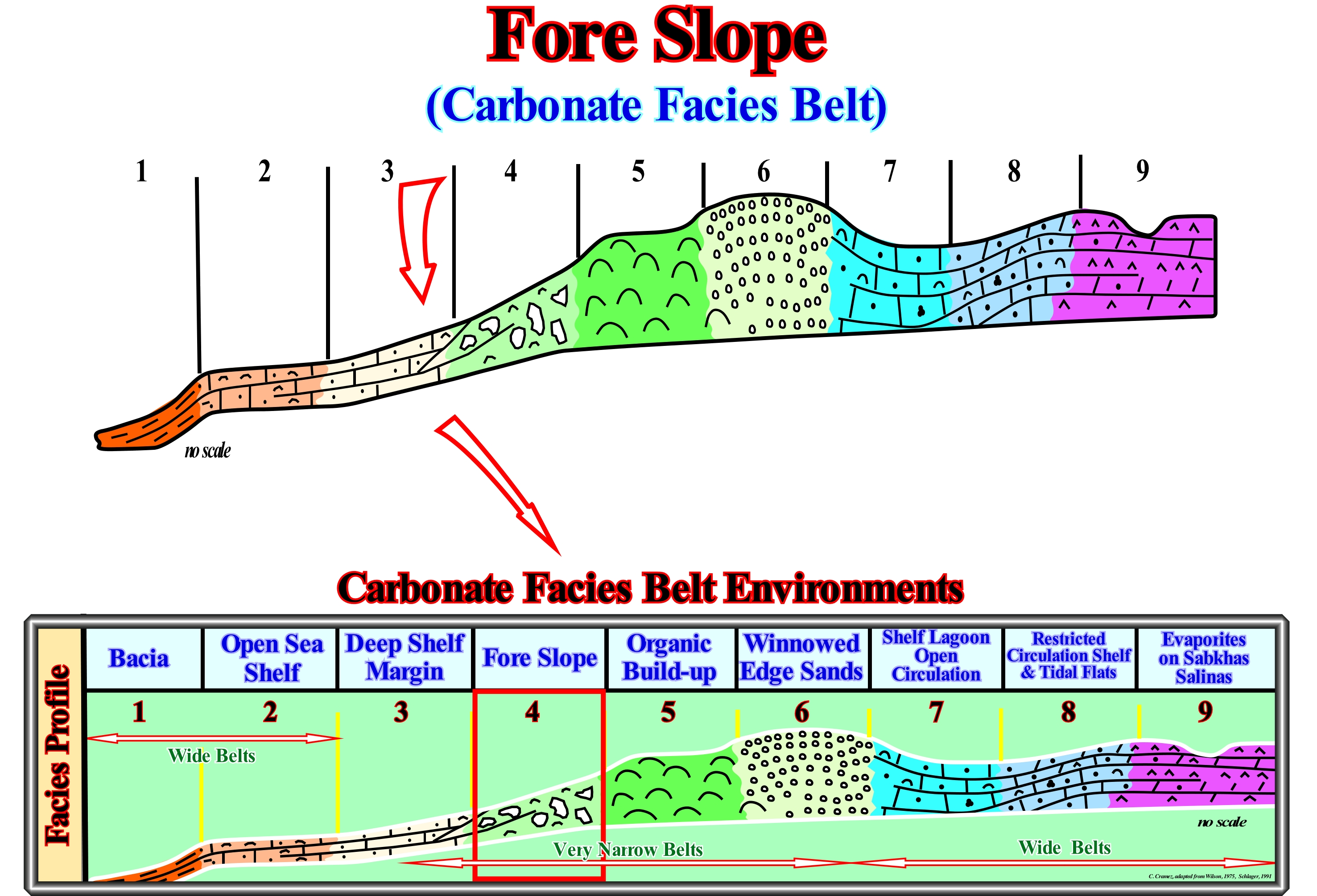
On this sketch, taken from Schlager (1991), the main environments found in a carbonated facies belt are summarized: (i) Basin; (ii) Open Sea Shelf ; (iii) Deep Shelf Margin ; (iv) Fore Slope ; (v) Organic Buildup ; (vi) Winnowed Edge Sands ; (vii) Shelf Lagoon with Open Circulation ; (viii) Restricted Circulation Shelf and Tidal Flats ; (ix) Evaporites on Sabkhas Salinas. This model does not say anything about the differentiation of carbonate belts environments induced by wind direction. In fact, sedimentary environments develop asymmetries in response to the dominant wind direction. The windward and leeward platforms have different morphologies and facies (lithologies), which are, sometimes, well marked on good quality seismic lines. In the study of carbonate platforms, it is necessary to take, always, into account that: (i) Carbonates are mainly of organic origin ; (ii) Carbonate build-up structures resistant to the action of waves and (iii) Carbonates undergo major diagenetic changes. That is why, Schlager (1991) says: (a) Carbonated sediments are not made, i.e., that carbonates are the result of an organic activity in a marine environment where sunlight and dissolved nutrients are available ; (b) Platforms construct edges that are resistant to the erosive action of waves and sliding resistant flanks ; (c) Rimmed carbonated platforms are constructed by an organic structures with a very rapid karstification and the flanks are stabilized by the karstification of the sea floor ; (d) The mineralogy changes after the deposition. Shallow-water carbonates are formed mainly by aragonite, magnesium-rich calcite and proto-dolomite, which after deposition stabilize in calcite or become dolomite. In the fore slope, the granulometry (grain size) is very variable. It ranges from mud-sized particles (clay) to gravel-sized particles. The extreme terms are, slightly, inclined slopes of mud with many sliding structures and sandy slopes, much more inclined and with oblique progradations. The biota is, mainly, composed of benthos (set of organisms that live on or on the sea floor) redeposited, with some benthic of deep-water and plankton. As illustrated, upstream of this environment are found reefs on the platform edge which emphasize the outer margin, not only on the rimmed carbonate platforms (connected to the mainland) but also on isolated platforms (not connected to the mainland). This is particularly true on the windward margin (platform margin on the side where the wind blows). Downstream of the fore slope lies the deep platform edge, which is under the action of the sea-waves (during calm sea), which can, however, be struck by storm waves. The fore slope is within the photic zone. Blocks of considerable size are frequent in this type of environment as well as fills of large cavities and mounds at the base of the slope. The most frequent microfacies are: (i) Bioclastic micro-breccias ; (ii) Lithoclastic conglomerates ; (iii) Grainstones (carbonate sedimentary rocks whose grains are not supported by micrite, the spaces between the grains are filled with laminar structure cement) and bioclastic packstones (carbonated rocks in which the grains are supported and have a matrix of micrite, this is, limestone) ; (iv) Floatstones (carbonate rock with millimetre grains in a fine limestone matrix) and (v) Rudite reefs. These microfacies (the term facies that has been defined in the field and which designates a lithology and associated fauna, is sometimes extended to the microscopic or geochemical scale) contrast with the micro-facies of the edge reefs (formed, mainly, of carbonate grains almost pure, of different sizes) of which the main ones are: (1) Bioconstructed limestone ; (2) Grainstones coated, bioclastic; (3) Coquinas (sedimentary rock, carbonate, formed by shells or shells of marine organisms ; (4) Floatstones ; (5) Rudites (a generic term used to designate granular sediments: calcirudite, feldspathic rudite, rudite (psephite) ; (6 ) Bafflestones (this is an autochthonous carbonate whose original components are connected, organically, during the deposit), etc.
(*) A zone with enough sunlight for photosynthesis to occur, i.e. between sea level and a depth where sunlight is about 1% of the surface light.
Foredeep Basin.........................................................................................................................................................................Bassin d'avant-fosse
Bacia de antefossa / Cuenca de antefosa / Vortiefe Becken / 前渊盆地 / Бассейн в передовой прогибе / Bacino di avanfossa
Accumulation of sediments coming from an orogen (mountain chain) and deposited on an adjacent region, relatively, little deformed by tectonics. In orognosy or orology, i.e., in the study of the mountains formation, under the weight of the orogen the terrestrial lithosphere, where the sediments accumulate, sinks and generates the necessary space (accommodation) to retain the imported sediments, mainly from the orogen, but also from of craton. It is in this type of sedimentary basin that the subsidence seems to have the same or more importance than the eustasy in the creation of available space for the sediments. On divergent continental margins, eustatic events are faster than tectonic events and the cyclicity is, thus, mainly induced by the accommodation created by eustasy (absolute or eustatic sea level changes). However, for many geoscientists, in the foredeeps, the available space for the sediments is created, mainly, by tectonics. Synonym with Foreland Basin.
See: « Basin (sedimentary) »
Foredune (Tail-dune).............................................................................................................................................................Dune d'estran (Avant dune)
Duna de praia alta (nebka litoral) / Ante-Duna / Verdünen, Stranddünen, Primärdünen / 滨沙丘 / Передовая дюна, хвостовая дюна / Dune battigia (prima duna) /
Dunes against the barrier bar or at the cliff and formed by the accumulation of beach sand carried by the wind against an obstacle, usually, against a tuff of halopsamophilous vegetation (which lives in the salty sands of the beaches). These dunes begin by having the shape of a tail, but acquire, quickly, the characteristic shape of a dome (almost always with less than one meter high). When the foredunes are more than one meter high, some geoscientists call them "rebdu" dunes, which may appear isolated or associated. (Albergaria Moreira, 1984).
See: « Berm »
&
« Cliff »
&
« Shoreface »

Fore-dunes form behind the nearshore at the crest of the berms, where vegetation or other obstacles trap the sand grains carried by the wind. Fore-dunes or tail-dunes are higher when the continuous accretion of sand is greater. The wind, with sufficient speed, erodes the sand grains of the shoreface and transports them upstream. Saltation is the main transport process by which the sand moves. It is a process where each grain of sand is carried by the wind near the surface by a series of small jumps. By the action of the wind the grains of sand are calibrated. The vegetation has a preponderant role in the size, shape and stability of the foreshore dunes. The first plants that colonize the fore-dunes are drought-resistant herbs capable of withstanding burial caused by the lateral movement of the dunes. As these plants grow through the sand, they contribute to the imprisonment of more sand and so the dunes increase in size. These dunes can reach more than 5 meters in height, but, in general, they rarely exceed one meter. Either way, these dunes act as destructive barriers to the action of waves and tides and are sources of sand for the beaches during periods of erosion. They also protect upstream areas behind the action of waves and salt water during storms. As these dunes have a large proportion of visible sand (20%), they are yellow dunes.
Foreland Basin.............................................................................................................................................................................Bassin d'avant-pays
Bacia de antepaís / Cuenca de antepaís / Vorlandbecken / 前陆盆地 / Бассейна в предгорье / Bacino di avanpaese, Bacino di foreland /
Accumulation of sediments coming from an orogen (mountain chain) and deposited on an adjacent region, relatively, little deformed by tectonics. In orognosy or orology, i.e., in the study of the mountains formation, under the weight of the orogen the terrestrial lithosphere, where the sediments accumulate, sinks and generates the necessary space (accommodation) to retain the imported sediments, mainly from the orogen, but also from of craton. It is in this type of sedimentary basin that the subsidence seems to have the same or more importance than the eustasy in the creation of available space for the sediments. On divergent continental margins, eustatic events are faster than tectonic events and the cyclicity is, thus, mainly induced by the accommodation cretaed by eustasy (absolute or eustatic sea level changes). However, for many geoscientists, in the foredeeps, the available space for the sediments is created, mainly, by tectonics. Synonym with Foredeep Basin.
See: « Basin (sedimentary) »
&
" Craton "
&
" A-Type Subduction (Ampferer) "
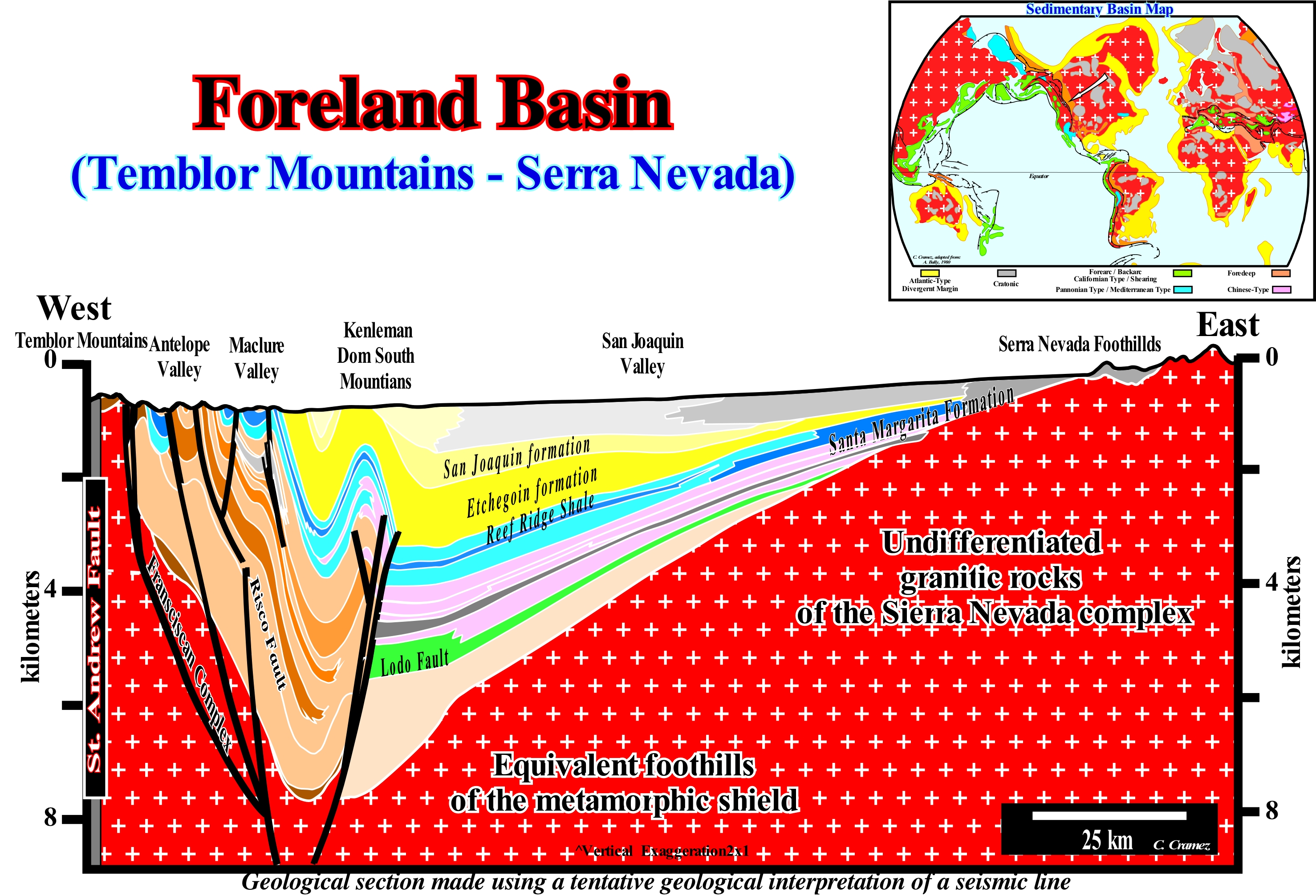
This geological section, based on a tentative geological interpretation of a regional seismic line, between the St. Andrews Fault* and the foothills of the Sierra Nevada (USA), illustrates the clastic wedge or foredeep basin created by the flexural subsidence induced by the thrusts overloading responsible for the formation of the Trembling mountains. It is in this type of sedimentary basins, associated with a A-type subduction (or Ampferer type) and created by a flexural subsidence, that certain principles of sequential stratigraphy are questioned. In fact, the P. Vail sequence stratigraphy scholl (Exxon Exploration Production Research) presuppose that eustasy (absolute or eustatic sea level changes**, which is referenced to the Earth's centre) is the main factor of the cyclicity observed in the sedimentary columns and that subsidence is secondary, although preponderant in the amplitude of creation of available space for the sediments (accommodation). This means the cyclicity of the sedimentary deposits observed in the field, seismic lines and electrical logs is induced by the relative sea level changes, which is the result of the combined action of absolute (eustatic) sea level and tectonics (subsidence or uplift of the sea floor), and not, just, by tectonic changes. In Atlantic-type divergent margins (extensional tectonic regimes preponderant), these conjectures are quite difficult to falsify (refute). However, for certain geoscientists, in convergent margins and, particularly, in the foreland basins, tectonic changes are faster and induced, mainly, by the weight of the thrust faults, it is possible that the role of flexural is more important than admitted by the Vail school, even in the sedimentary cyclicity. It is important not to forget that in foreland basins the subsidence is, basically, created by the overloading of the thrust faults forming the mountain chains and that their uplift produces an important terrigeneous influx. With the continuation of the shortening, the sediments, deposited in the foredeep, are shortened, progressively, and incorporated in the mountain range. This progression of the mountain chains toward the cratons (tectonically stable areas formed by Precambrian igneous or metamorphic rock and, often, outcropping) produces a progressive displacement of the flexural bulge points toward the craton (shield). These points are uplifted forming erosional areas, in the distal part of the substratum of the foredeep where the amplitude of subsidence changes abruptly. In certain basins of this type, important reef constructions are, sometimes, associated with the peripheral bulges. Foreland basins often develop over a divergent continental margin (substratum of the foredeep) in association with the closing of an ocean*** and the formation of a converging margin. At first, the terrigeneous influx responsible of the turbiditic deposits which fossilized the basal unconformity of the foredeep comes mainly from the craton. However, as the mountain range uplift and prograde toward the craton, the origin of the terrigeneous influx can be inverted. The petroleum potential of this type of sedimentary basin is very variable. Often, it is associated with the underlying basins. In the onshore of Venezuela, the potential generating petroleum system of the foreland basin (foredeep), in Maracaibo and Maturin regions, is very weak. The hydrocarbon richness of these regions is associated with a generating petroleum subsystems (source-rocks) of the underlying sediments, i.e., of the Cenomanian-Turonian organic rich transgressive carbonated shales, deposited in ta back arc basin (in Maracaibo area), and a divergent margin in Maturin There may also be good potential source-rocks, in the lower sediments of the foreland basin, in particular, in the shales deposited in restricted deep environments, which allow the accumulation and preservation of organic matter, as is the case, for example in the Caucasus foredeep.
(*) St. Andrew fault, located in California, is a geological strike-slip fault that is, at the same time, a transform fault. It separates the Pacific lithospheric plate from the American lithospheric plate. Its trace crosses the cities of San Francisco and Los Angeles. It is responsible for the catastrophic earthquakes affecting this cities.
(**) The absolute (eustatic) sea level is a function of: (i) Tectono-Eustasy that is controlled by the volume variation of the ocean basins in association with oceanic expansion following the break-up of the supercontinents ; (ii) Glacio-Eustasy, which is controlled by the water volume in the oceans as a function of the amount of ice (assuming that the amount of water, in all its forms, is constant since the Earth's formation, about 4.5 Ga) ; (iii) Geoidal-Eustasy which is controlled by the distribution of ocean water caused by variations in the Earth's gravity field (where gravity is stronger than normal, sea level is thrown to the Earth's centre) and (iv) Thermal Dilation of ocean or Steric sea level rise (if the temperature of the oceans increases, the density of the water decreases and, for a constant mass, the volume increases).
(***) Collision between two divergent margins with opposite vergence, such as the northern and the southern divergent margins of the Tethys sea.
Foreset (Chronostratigraphic line)...........................................................................................................Segment incliné vers la mer
Segmento inclinado para o mar / Segmento inclinado hacia el mar (línea cronostratigráfica) / Segment zum Meer hin geneigt / 向海倾斜的分部 / Промежуточный ряд / Segmento inclinata verso il mare /
One of the three segments that form a chronostratigraphic line: (i) Upper Horizontal Segment (Topset) ; (ii) Seaward Dipping Segment (Foreset) ; (iii) Lower Horizontal Segment (Bottomset). The seaward dipping segment represents deltaic or continental slope sediments, function of the scale (do not confuse the slope of a delta between 20 and 60 meters with the slope of a deltaic building, which is a continental slope).
See: « Parallel Configuration »
Foreset Bed (Delta)........................................................................................................................................................................................Couche frontal
Camada frontal (inclinada) / Estrato frontal / Geneigte Scinten / 前积床 / Передовой пласт (дельты) / Strato frontale (delta) /
Dipping bed or group of beds of delta sediments deposited on the prograding margin of a delta. In a sand dune, the layers deposited on the sliding face (leeward, side protect of wind) are also called frontal layers (of a dune). Synonymous with Seaward Dipping Bed of a delta (deltaic slope).
See: "Delta”
&
“ Bottomset bed (delta) ”
&
“ Topset Bed (delta) ”

In a deltaic sedimentary environment, the sedimentary particles, transported by the distributive channels, are deposited according to a progradational pattern. The coarser ones are the first to be deposited. They form a series of sub-horizontal layers called "Topsets". The dipping seaward beds are called "Foresets". The thinnest sedimentary particles, either at sea or in a lake, are transported further and deposited in, more or less, horizontal layers, referred to as "Bottomsets". There are deltas without topsets (upper layers). The presence of the frontal layers (foresets) is mandatory. A delta, by definition, must to prograde seaward (outbuilding). Aggradation (upbuilding) is not essential. A delta progrades toward a water-body. The water-course extends its distributive channels to the outer border of the delta. When this happens, the foreset (dipping seaward) are covered by the topsetsl "Upper layers", which are formed by sandy sediments, mainly. In a delta, the chronostratigraphic lines (more or less, the bedding planes) may have a sigmoid or oblique geometry. In the first case, there is outbuilding (progradation), but also upbuilding (aggradation). The topsets, foresets and bottomsets are well individualized. This is the case not only on the field, but on the seismic lines, as well (when the seismic resolution is appropriated). In the second case, there is only "outbuilding", i.e., that the foreset layers are present and, sometimes, in association with the bottomsets. These two geometries correspond to very different depositional mechanisms. When the geometry is sigmoid, there has been aggradation and progradation of the depositional coastal break of the depositional surface (more or less, the shoreline). This implies a rise in relative sea level, that is, an increase in available space for the sediments (accommodation). When the geometry is oblique, there has been, just, progradation of depositional coastal break of the depositional surface. This requires an important terrigeneous influx, but not a significant relative sea level rise. In this case, it can be said there is no increase in accommodation (a result of the combined action of eustasy* and tectonics). The sedimentary particles transported to the depositional coastal break of the depositional surface (more or less the shoreline) are forced to settle as foreset layers, in the delta slope, where there is available space for the sediments. It can also be said in this case the rate of creation of available space is less than the sedimentation rate. An oblique geometry (without aggradation) can also be the result of an erosion of the topset. When a geoscientist says when there is a relative sea level rise (marine ingression) there is deposition, he commits more than a small language error. Sediments (sequence-paracycle) are, mainly, deposited during the stability period of relative sea level occurring after each increment in relative sea level rise** (eustatic paracycle set). Relative sea level rises (marine ingressions may be in acceleration, i.e., increasingly important or in deceleration, when increasingly smaller) produce just a small ravinment surface on the pre-existing topography and creates the available space for the sediments. The space available for the sediments is filled (totally or partially) during the stability period of the relative sea level function of the terrigeneous influx, forming what is called a sequence-paracycle. It is interesting to note the difference between a delta systems tract (lateral association of several synchronous and genetically associated depositional systems) with the progradation of systems tracts. What many geoscientists call sedimentary system tracts is often a progradational or retrogradational set of sedimentary systems tracts. Within a sequence-cycle, two sedimentary systems tracts groups (highstand and lowstand) are considered. They are formed by subgroups : Highstand Prograding Wedge (HPW) ; Transgressive Interval (TI ); Lowstand Prograding Wedge (LPW) ; Submarine Basin Floor Fans, (SBFF) ; Submarine Slope Fans (CST). Each systems tracts sub.group is composed, generally, by a set of systems tracts.
(*) Eustasy or eustatism corresponds to the absolute (eustatic) sea level changes, that is to say, the global sea level, referenced to the Earth's centre.
(**) A relative rise in sea level rise, in general, corresponds to a set of eustatic paracycles either in acceleration (increasingly important) or in deceleration (increasingly lsmaller), without any relative sea level fall between them.
Foreshore.............................................................................................................................................................................................................................Haute plage
Praia-alta / Parte trasera de la playa / Hinterstrand / 滨,滨 / Береговой полосе / Retrospiaggia /
The upper part of the beach, with a steep slope, only reached by the waves in the equinoxial tides and during the storms or, in other words, the upper zone of the beach, located above the action of the waves and the ordinary tides and in which, consequently, the sand is, usually, dry. It is, in general, formed iduring thunderstorms. Most of the time it is formed by beach berms formed in association with great storms.
See: « Shoreface »
&
« Littoral »
&
« Beach »
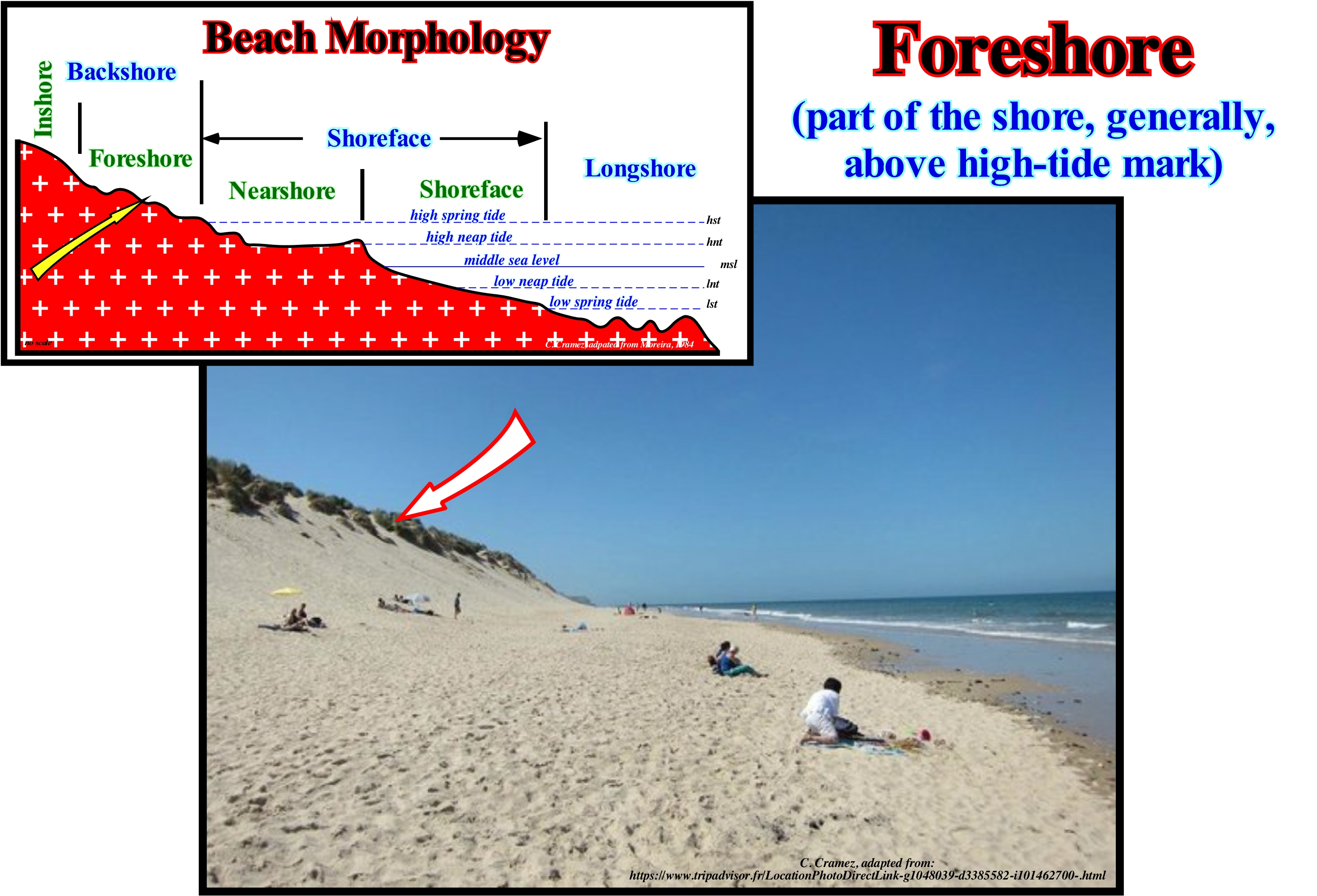
In the Atlantic islands, the beaches of coarse debris are called pebble beaches or just pebbles. The beaches made up of sand, pebbles and blocks are the mixed beaches. Sandy beaches are the most frequent. The beaches can have a rectilinear or arched shape. The curvature of the beach is defined, morphometrically, as the radius of the circumference whose string is the line segment joining the extreme points of the beach. The length, width, orientation and slope of the beach are other important parameters that often have to be taken into account. The slope (dip) of the beach varies with the granulometry of the materials. It is larger when the beach is formed of coarse sand (more or less, between 20°/22°). On beaches made of pebbles, the slope can reach 20°/30°. A beach is characterized by a specific morphology. The classification of the beaches varies with the geoscientists. As illustrated above, theoretically, five strips can be recognized in the morphology of a beach: (i) Inshore or Backshore ; (ii) Foreshore ; (iii) Nearshore ; (iv) Shoreface ; (v) Longshore. The inshore (backshore) form of relief that constitutes the inner limit of the beach and that can be a cliff or a barrier bar, isolating or not an interior lagoon. The foreshore is the upper part of the beach, with steep slope, only reached by the waves in the spring high-tides and storms. When extensive, the foreshore has obstacle dunes in form of dome ( foreshore dunes). The surface reached by the waves is modelled in berms. The nearshore is part of the beach that extends in the space reached by the swash currents, between the levels of neap high-tides and low-tides. It is separated from the foreshore by the lower berm of the beach and the shoreface the inflection line. The shoreface corresponds to the lower part of the strand. It encompasses the space that extends between the limits reached by the low-tide in, in neap and spring tides. The slope is very weak and the material is thin, locally containing but coarse materials transported longitudinally. The longshore is the part of the beach always submerged that extends offshore, from the limit of the lower tides, by an badly defined space that for some geoscientists , is the surf strip. The bottom of the longshore is modelled by longshore ridges and longshorerunnels.
Foreshore (Intertidal)...............................................................................................................................................Plage intertidale (Entre marées)
Praia intramareal / Playa intramareal (entre mareas) / Wattenmeer / 潮间带 / Береговая полоса, затопляемая во время прилива / Piano mesolitorale /
Morphogenic range of a beach bounded between low and high tide. It corresponds to the actual beach of certain geoscientists (G. S. de Carvalho, 1973) and to the proximal part of the beach of Anglo-Saxon geoscientists (S. Judson and S. Richardson, 1995).
See: « Shoreface »
&
« Littoral »
&
« Karst »
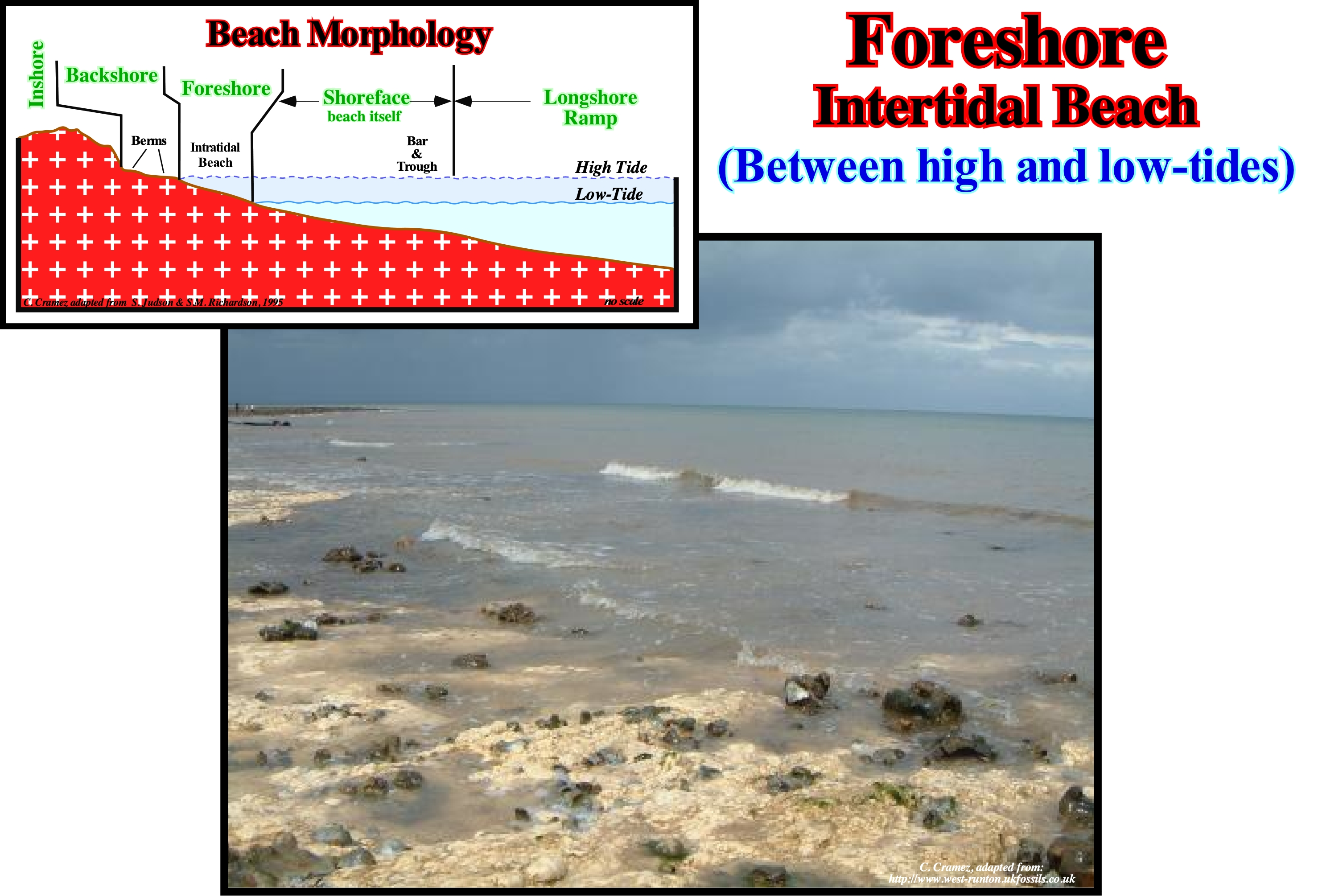
The intra-tidal beach of the Anglo-Saxon geoscientists corresponds to the morphogenetic range of a beach, which the great majority of European geoscientists call the nearshore, and which they define as the part of the beach that extends in the space reached by the swash currents, between levels of neap high and low-tides. The foreshore or inter-tidal beach corresponds, roughly, to the intertidal zone, which American geoscientists call "foreshore" or "nearshore". It is the area exposed to air during low-tide and submerged during high-tide or the area limited between the tidal lines. The inter-tidal beach may include different habitat types, either steep rocky cliffs, sandy beach or salt flats. The inter-tidal beach may be narrow, as is the case in almost all the islands of the Pacific Ocean The difference in tidal amplitude is very small. It can also be very wide, when a little inclined beach interacts with a high tide of great amplitude (as it is also the case of an important relative sea level rise over slightly inclined substratum). Geoscientists divide the inter-tidal area into three zones: (i) Low; (ii) Middle and (iii) High, depending on the average exposure of the area. The low inter-tidal zone, which is adjacent to the subtidal zone, is only exposed to the air during low tides. It is, basically, a marine area. The middle inter-tidal zone, on the other hand, are regularly exposed to the air and submerged during medium tides. The upper intertidal zone is just covered with water during high-tides. For the most part it represents a terrestrial habitat. The upper intertidal zone is adjacent to the swash zone (i.e., the surf zone). It is above the upper level of the medium tide but still receiving the splash of the waves. On the shores exposed to a strong action of the sea-waves, the inte-tidal zone is influenced by the waves. Salt-spray or sea-spray extends above the high-tide line.
Foreshore Drift (Beach Drifting)....................................................................................................................................Courant en zigzag
Corrente en zigue-zague (corrente de deriva de praia)/ Corriente en zigzag / Strand Strömung / 海滩漂移 / Зигзагообразное течение / Deriva di spiaggia, Corrente de spiaggia /
Current formed in the surf zone when this is oblique to the shore, due to the accumulation of water and sediments. It is caused by the uprush and backwash currents, that is to say, by the surge currents.
See: « Stream »
&
« Uprush Current »
&
« Surf Zone »

When the sea-waves propagate perpendicularly to the shoreline, from the moment a wave breaks (transformation from a oscillation wave into a translation wave), the uprush current flows toward the beach, along the direction of the wave propagation. Since the uprush current loses energy, it reverses (it changes direction flowing seaward). It creates the backwash current that flows seaward following the slope of the sea floor. When the wave propagation is perpendicular to the shoreline, it is evident the flow direction of displacement of the uprush and backwash currents is the same. However, when the wave propagation direction is oblique to the shoreline, the direction of the backwash current (direction of the sea floor slope) is not the same as the direction uprush current, which flows along the propagation direction of the sea waves. It is in such a case (wave direction oblique the shoreline) that a zigzag current forms (the "zig" is the uprush current and the "zag" is the backwash current). As, in general, the uprush current (zig) is more important than the backwash current, the combination of the two currents produces, more or less, parallel to the coastline that travels in the direction of the uprush (direction of sea wave propagation), which is known by the name of foreshore drift. As shown in this photograph, taken in fair weather wave, but when there are waves they are oblique to the coast, the zigzag current erodes the beach and transports the sediments to the places where their energy is weaker or when, as in this example, a barrier, either natural or artificial, opposes its flow. It is for this reason that in many coastlines, as illustrated in this figure, jetties (piers) are placed perpendicularly to the shoreline to force the foreshore drift (or littoral drift) to deposit the sedimentary particles that it carries. In this example, where the shoreline is North-South, there is more sand (larger beaches) northward than southward of the jetty, since the current moves from North to South (the wave direction is probably NE-SW).
Foreshorerunnel........................................................................................................................................................................Sillon d'avant-côte
Sulco pré-litoral (caneiro) / Depresión prelitoral / Strandrinnen / 抑郁症的临滨 / Береговой спуск / Depressione della spiaggia sottomarina /
Depression in the nearshore (beach itself) induced by the interaction of waves and tides and whose topography is submerged or sub-aerial function of the tide cycle.
See: « Karst »
&
« Erosion »
&
« Wave Action Level »

The coast (littoral) is the name given to the strip of the continent that is in contact with the sea or at phenomena characteristic of that area. Some geoscientists restrict the littoral to the inter-tidal zone. Others extend it inland, by a space whose boundaries are not always easy to define, and to the offshore by the wave breaking line. Based on the distribution of the coastal biocenoses (living beings that coexist in a defined space called a biotype) and depending on the times of emersion, the coastal space is divided in terrain ranges (bands) or zones (floors), parallel to the shoreline: (i) Supralittoral Zone ; (ii) Mesolittoral Zone and (ii) (iii) Infralittoral Zone. The supralittoral zone comprises the space reached directly by the sea-spray (salt-spray), above the level of spring high-tides, and which is always emerged. The mesolittoral zone corresponds to the intertidal band. The infralittoral zone is located below the level of the spring high-tides, and which is always immersed. In the shoreface (also called low tide-terrace) there are undulations of weak amplitude (3-15 centimeters), more or less, linear and parallel to each other and to the line of breaking. These ripples, which are called beach ripples can be symmetrical or dissymmetrical, are created by the turbulent flow of the swash currents (in particular by the uprush of the backwash current). It is the trough of these ripples that certain geoscientists call foreshorerunnels. In general, at the outer boundary of the shoreface, i.e., on the longshore below the level of spring low-tides, there are sometimes undulations of greater amplitude, which can reach about one meter. The crests of these longshore undulations are the longshore ridges or longshore bars while the troughs are the foreshorerunnels. Most of the Anglo-Saxon geoscientists make the distinction between nearshore and shoreface. They consider just the "foreshore" which is equivalent to the "bas de plage" (between "arrière plage" and "avant-côte") of the French geoscientists and which corresponds to the set of the middle-beach ("Praia-Média") and the the shoreface ("Praia Baixa") of certain Portuguese geoscientists. However, some Portuguese geoscientists, such as Soares de Carvalho, also, encompass the shoreface and the middle-beach in a single unit called the beach itself ("Praia propriamente dita"). The foreshorerunnels form on the part of the beach that is always submerged and extends outwards from the limit of the lower tides and which corresponds to the strip or zone of surf. Wave breaking model the seafloor forming ridges (11) and troughs (12), as illustrated in this scheme. These structures should not to be confused with the ripples formed on the longshore, which corresponds to the lower part of the strand (space limited by the neap and spring low-tide). The shoreface ripples are due to the turbulent flow of the swash currents, and in particular the backwash current (the current which flows seaward following the sea floor bottom slope). The longshore undulations are much larger. They are created by the breaking of the waves. On the other hand, when the surface of the nearshore is reached by the waves (during the spring high-tides), it is modelled on terraces called berm steps (3), which are formed by a landing or beach berm (5 ) and an abrupt (7). The inflection line between the berm and the abrupt of each step is called the berm crest (6). The crest of the upper berm is the crest of the foreshore (4). The beach steps (nearshore) have, in general, smaller dimensions than the seismic resolution of conventional seismic lines. However, in high resolution seismic lines, where these structures may be visible, they should not be interpreted as retrogradations of the depositional coastal break of the depositional surface. In fact, during a transgressive episode, at each relative sea level rise, the depositional coastal break of the deposition surface is displaced continentward (function of the morphology of the lower unconformity bounding the associated sequence-sequence) moving further away from the basin edge, increasing the extension of the shelf and the water-depth (water column). It can be said the retrogradation of the depositional coastal break is induced by a relative sea level rise, whereas the berms formation of the nearshore are induced by the erosional waves action, particularly, during the periods of high-tide. Within the retrogradational sequence-paracycles, particularly, those forming the transgressive interval of a sequence-cycle, the sediments prograde seaward.
Foreshortened Stratigraphy (Descending systems tracts).......................Stratigraphie (Systèmes descendants)
Estratigrafia encurtada / Estratigrafía (sistemas descendentes) / Verkürzt Stratigraphie/ 按透视地层 / Стратиграфия (в ракурсе) / Stratigrafia scorciata, Stratigrafia (sistemi verso il basso) /
Study of the paracycles-sequence when their thickness is smaller (considerably) than the biostratigraphic estimates of the water-depth. Descending or bordering systems tracts exist just in a forced regression.
See: « Shelf Wedge Systems Tract»
&
« Biostratigraphy »
&
« Stratigraphic Cycle »

In sequential stratigraphy, i.e., when the stratigraphic column is sub-divided into sedimentary packets bounded by unconformities (erosional surfaces induced by relative sea level falls), within a sequence-cycle (stratigraphic cycle), which is induced by an eustatic cycle of 3rd order, whose duration varies between 0.5 and 3/5 My, two large groups of sedimentary sedimentary systems tracts are, usually, recognized. From bottom to top: (i) Lowstand Systems Tracts Group (LSTG), which is formed by the following subgroups: a) Submarine basin floor fans (SBFF) ; b) Submarine slope fans (SSF) ; Lowstand Prograding Wedge (LPW) and (ii) Highstand Systems Tracts Group (HSTG), which is formed by two subgroups. The lower sub-group is the Transgressive Interval (TI), and the upper subgroup is the Highstand Prograding Wedge (HPW). When the relative sea level begins to fall, particularly, during a forced regression, descending sedimentary systems tracts (DST), forming the Bordering Prograding Wedge (BPW), are deposited. The relative sea level is a local and referenced to the base of the sediments (top of continental crust) or to the sea floor, is the result of the combined action of tectonics (subsidence or uplift of the sea floor) and the changes of the absolute (eustatic) sea level which is supposed to be global and referenced to the Earth's centre. In the model proposed by P. Vail, with which not all geoscientists agree, the descending sedimentary systems tracts are deposited on top of a type II Unconformity. For P. Vail, the descending systems tracts are deposited in association with a small relative sea level fall, which did not set the sea level lower than the basin edge, which coincides with the shoreline in highstand geological conditions. These sedimentary systems tracts correspond to the terminal part of the sequence-cycle. They are deposited in association with: a) A fluvial incision in the coastal plain ; (b) A progressive subaerial exposure ; (c) A sedimentary transit on the continental slope and formation of submarine canyons. It can be said in a descending sedimentary systems tracts there are: (1) Few microfossils ; (2) High values of δ18O*, suggesting, probably, lowstand geological conditions (absolute sea level fall induced by glaciations) ; (3) Onshore erosion ; (4) No deposition on the coastal plain ; (5) Thinning of downstream and (6) A foreshortened stratigraphy. In this type of stratigraphy the sedimentary thickness (without compaction) of the Bathydecreasing stratigraphic sections is smaller than the difference of paleo-water depth between the base and the top, and in which a forced regression process is almost always present. For P. Vail, the boundary of the sequence-cycle must be placed underneath the forced regression deposits. For others geoscientists such as Miall, the unconformity must be placed on top. Theoretically, the upper limit of the sequence-cycle is, easy, to recognize in nonmarine environments. It is represented by an sharp erosional unconformity. However, even in this case, it is difficult to distinguish it from other erosional surfaces, such as those created by autogenic incision of a water-course. In a forced regressive system, the problem is to find the upper limit of the sequence-cycle. It has been suggested that such a limit represents the beginning of relative sea level fall (see Forced Regression). Do not forget, that in sequential stratigraphy, within a sequence-cycle: (i) Above the depositional base level there is erosion and transport ; (ii) Underneath the depositional base level, there is sediment accumulation and preservation ; (iii) In sedimentary basins connected to the sea, the baseline level is controlled by the combination of absolute (eustatic) sea level and tectonics ; (iv) In endorheic basins, it is the climate and tectonics that control the base level variations ; (iii) When the base level is high, whether it corresponds to the relative sea level or not, there is plenty of space to be filled ; (v) When the base level is low, there is little space that is easily filled by the sediments ; (vi) When the baseline level is high or increasing, the sediments are not distributed throughout the basin, but are confined in continental environments and near the coastline ; (vii) If baseline level continues to rise (increasing accommodation), the shoreline will retrograde, progressively, creating marine transgressions emphasizing the maximum marine flood of the sequence-cycle ; (viii) When the base level is low or falls, the accommodation is quickly filled and a continuous sedimentary influx produces a sedimentary regression ; (ix) In basins connected to the sea, where the baseline level of deposition falls significantly due to a relative sea level fall, there is exhumation and erosion of previously coastal and marine areas with a possible seaward displacement of systems ("forced regression"), if the relative sea level fall is not very important before forming an unconformity (erosional surface), which limits a new sequence-cycle, materialized, in the proximal sector of the basin, by the superposition of continental sediments on previously deposited sediments and in the deep basin sector by turbidite depositional systems.
(*) Evaporation and condensation of water are the two processes that most influence the ratio of oxygen isotopes in water. Water molecules containing light oxygen (δ16O) tend to evaporate more easily than heavy water (δ18O). At the same time, heavy water vapor (δ18O) tends to condense more easily. In an interglacial phase: (i) Water evaporating from the ocean is poorer in (δ18O) than sea water, which is enriched at (δ18O) ; (ii) Condensed water plus precipitation water (on the sea or on land) is richer in (δ18O) than water vapour which is increasingly impoverished in (δ18O) ; (iii) The δ16O/δ18O ratio of seawater is constant, since all evaporated water returns to the sea. During glacial epochs: (i) Evaporated water depletes in δ18O and seawater becomes richer in δ18O ; (ii) Condensed water, plus precipitated water, is richer in δ18O than water vapour which is increasingly impoverished in δ18O ; (iii) Water depleted in δ18O is stored as ice ; (iv) Sea water is enriched in δ18O , since there is more ice, plus δ18O of sea water is large. In other words, high δ18O values in sea-water and low ice values indicate the occurrence of glacial epochs (low temperatures) and, consequently, absolute (eustatic) sea level declines. Indications of low δ18O in sea-water indicate higher temperatures, which implies less global ice cover and less saline waters and an absolute sea level rise. This is because heavier water vapour condenses first and then is followed by a large amount of light precipitation that reaches the oceans via the drainage of the watersheds to the sea, producing a dilution effect. Scientists associate the low δ18O values in seawater with strong freshwater traces, which on a global scale suggests higher temperatures.
Forestepping.........................................................................................................................................................................Géométrie progradante
Geometria progradante / Geometría progradante / Progradierender Geometrie / Progradational几何 / Проградационная геометрия / Geometria progradazionale /
Geometry resulting from a succession of seaward and upward displacements of the depositional coastal break. This type of geometry is typical of regressive deposits, in which successive depositional coastal breaks, which correspond, often, to the basin edge, advance significantly seaward with aggradation (vertical construction or upbuilding) variable but always positive.
See: « Retrogradation »
&
« Marine Regression »
&
« Downlap »

As illustrated on this tentative geologically interpretation a Canvas auto-trace of a detail of a seismic line from the Gulf of Mexico, the post-Pangea continental encroachment cycle is composed of two sedimentary phases, which, globally, have quite different geometry. The first phase, i.e., the transgressive phase has a retrogradational geometry. The thickness of the sedimentary intervals that compose it, increases continentward, before onlapping against the pre-Pangea infrastructure. The second phase, which fossilizes the transgressive phase, is the regressive phase. It is characterized by a progradational geometry. Contrary to what happens in the transgressive phase, during the regressive phase, the sedimentary intervals thicken seaward, before condensed and disappearing in the deep parts of the basin. During the transgressive phase, retrogradation is preponderant. During the regressive phase, outbuilding (progradation) is dominant. During the transgressive phase, the shoreline moves (globally) continentward. During the regressive phase, the shoreline moves seaward. The water-depth (water column) increases during the phase transgressive and decreases during the regressive phase. During the transgressive phase, periods in which the basin a continental platform (shelf) are predominant. That is not the case for most of the regressive phase. On the other hand, during the transgressive phase, the absolute (eustatic) sea level (measured in relation to a fixed reference point, usually, the Earth's centre), rises globally. The dimensions of the continental platform (shelf) increase as the shoreline is displaced continentward, what implies a significant decrease of the sedimentary charge. On the contrary, during the regressive phase, the absolute sea level, globally, falls. The water-depth (water column) diminishes at the same time the sedimentary influx increases (more continental surface is exhumed). A major downlap surfaces (underlined in this tentative interpretation by a dashed line) separates the two phases. It marks a depositional hiatus, which increases, progressively, towards the deep part of the basin. This surface, which marks the maximum of the marine ingression (landward displacement of the shoreline induced by successive relative sea level rises), suggests the most probable location of the potential marine source-rocks deposited during this continental encroachment cycle. As can be easily seen, in this particular case, the organic matter of the potential marine source-rocks, associated with the downlap surface 91.5 Ma (Cenomanian/Turonian) is, probably, mature (reached the window of oil), downstream of the basin edge, during the maximum of transgressions, and immature upstream. In the transgressive phase (retrogradational geometry), it is interesting to note : (i) The normal faults become flattened on the salt horizon and (ii) Reef constructions emphasize, often, the basin edge. As all clastic sediments come from the continent, it can be said all sequence-paracycles, that make up the different sedimentary systems tracts sub-groups, which form a sequence cycle, have a progradational geometry, once the shoreline moves to the seaward as sedimentation takes place. During marine ingressions (relative sea level rise increments), the shoreline moves to the mainland increasing the available space for the sediments. After each marine ingression there is a stability period of relative sea level during which the available space for the sediments (accommodation), created by the marine ingression, is filled as the coastline, due to sediment deposition (sedimentary regression), moves seaward. The increasingly important set of marine ingressions induces the deposition of a set of increasingly smaller sedimentary regressions that, collectively, form a retrogradational sedimentary interval which geoscientists, simply, call transgressions or sedimentary transgressions. On the contrary, the set of marine ingressions increasingly smaller creates a set of increasingly important sedimentary regressions which, collectively, form a progradational sedimentary interval, that geoscientists call, simply, regressions,
(*) In the terminology used in this glossary a "Sedimentary Regression" is a sequence-paracycle, generally, formed by a single sedimentary systems tract, during which the shotreline travels seaward, in general, without aggradation. "Regressions" or "Sedimentary Regressions" is the set of increasingly important sedimentary regressions, which collectively have a progradational geometry. "Transgressions" or "Sedimentary Transgressions" is the set of increasingly important marine ingressions and sedimentary regressions, increasingly smaller that they induce, which, collectively, have a retrogradational geometry.
Fork (Arm, distributary)...........................................................................................................................................................................Défluent (Distributaire)
Distributário, Distributivo / Canal distributario, Brazos / abzweigender Arme / 分流河道 / Рукав (реки) / Canale emissario /
Any of the numerous arms in which a river divides to reach its delta.
See: « River »
&
« Delta »
&
« Stream »
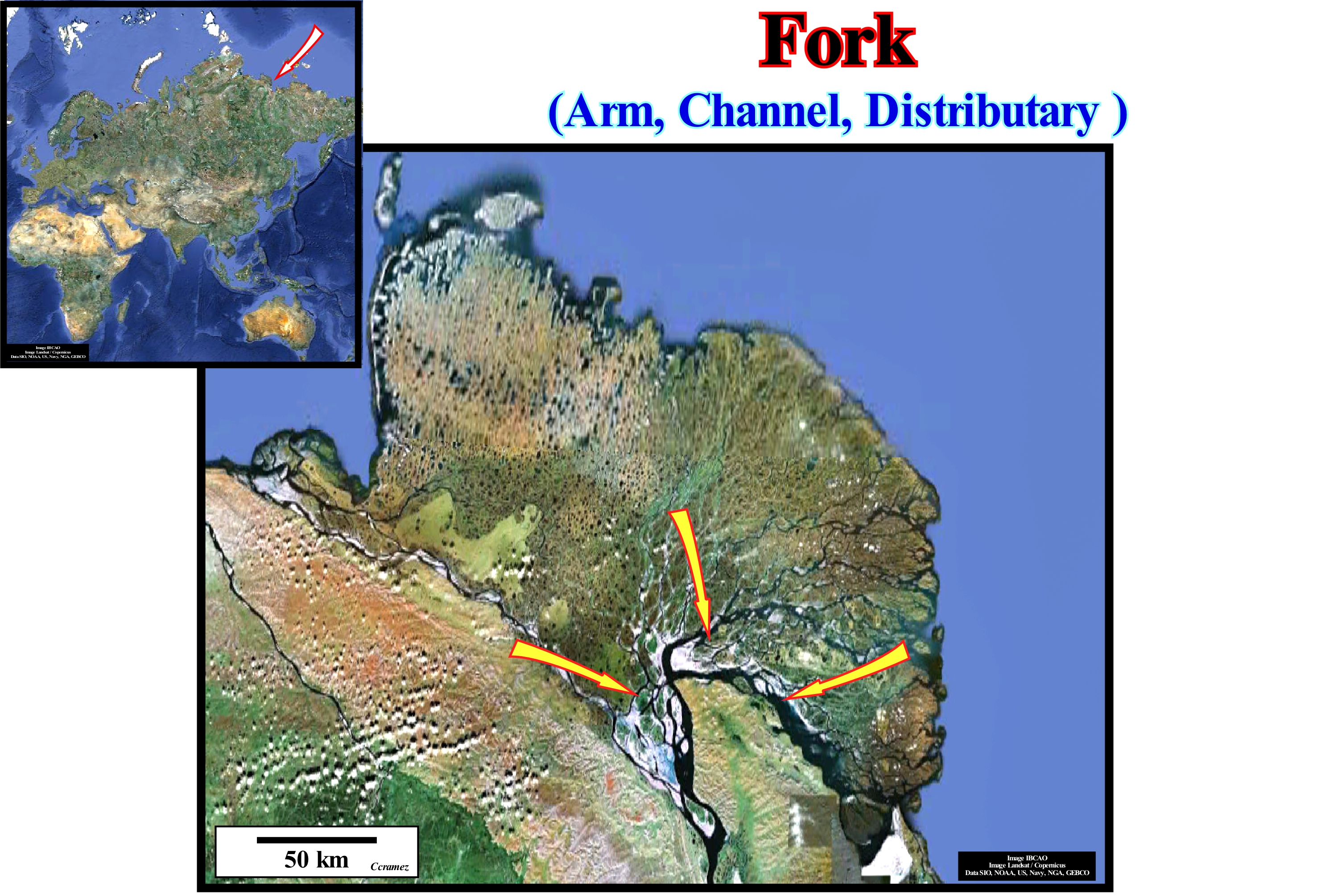
A distributary or distributive channel is a stream of water, which branches out or flows out of the main channel. This phenomenon is known as the bifurcation of a river. The forks or distributives, as illustrated in this figure, are very common in the deltas associated with rivers. The opposite of a distributive (or distributary) is a tributary of a river. Distributaries, usually, occur as streams near the lakes or the sea. They also occur on the onshore, such as in closed or endorheic basins (closed drainage basin, which holds water and does not allow any flow to other water-bodies or when a distributive current branches as it approaches the confluence with a more important current. In some cases, a smaller distributary can steal so much water from the main channel that it can become the main path of the stream. The study of the deltas, clearly, shows the distributary channels control the flow of sediments into the ocean. A relationship exists, sometimes, between the number of distributary channels, the length of the river and the gradient of the delta. These relationships are valid for delta controlled or are, heavily, influenced by sea waves, discharge of rivers, tides or ice. Often, the delta distributaries result from the pendulum effect of the delta lobes. The currents are forced to move sideways as long as a lobe is formed. Naturally controlled deltas, in contrast to man-controlled deltas such as the Klinaklini (Canada, British Columbia), have distributary channels acting as overbank sources during flood periods. Anthropogenically controlled deltas, such as the Po Delta, have distributive channels that control floods and also low runoff. Anthropogenic controls strongly influence the rate of natural delta progradation induced by changes in the terrigeneous influx. They control the position of the channels distribution but, also, the subsidence induced by the extraction of natural gas and groundwater. Even under these control conditions, the Po delta holds about 16% of the sedimentary particles carried by the canals, which rise at an annual rate of 4-10 cm in relation to the flood-plain.
Formation (Geological)..................................................................................................................................................................Formation (Géologique)
Formação / Formación (geológica) / Formation (Geologie) / 组 / Геологическая формация (свита пластов) / Formazione (stratigrafia) /
A fundamental geological unit of litostratigraphy that can be mapped. A geological formation may have limits other than unconformities. The downlap surface that limits the transgressive interval of a sequence-cycle is, sometimes, a boundary ("time transgressive boundary" of English-speaking geoscientists). The names of the geological formations are, sometimes, derived from geographical names, where they are most clearly found.
See: « Stratigraphic Cycle »
&
« Geological Section »
&
« Systems Tract »
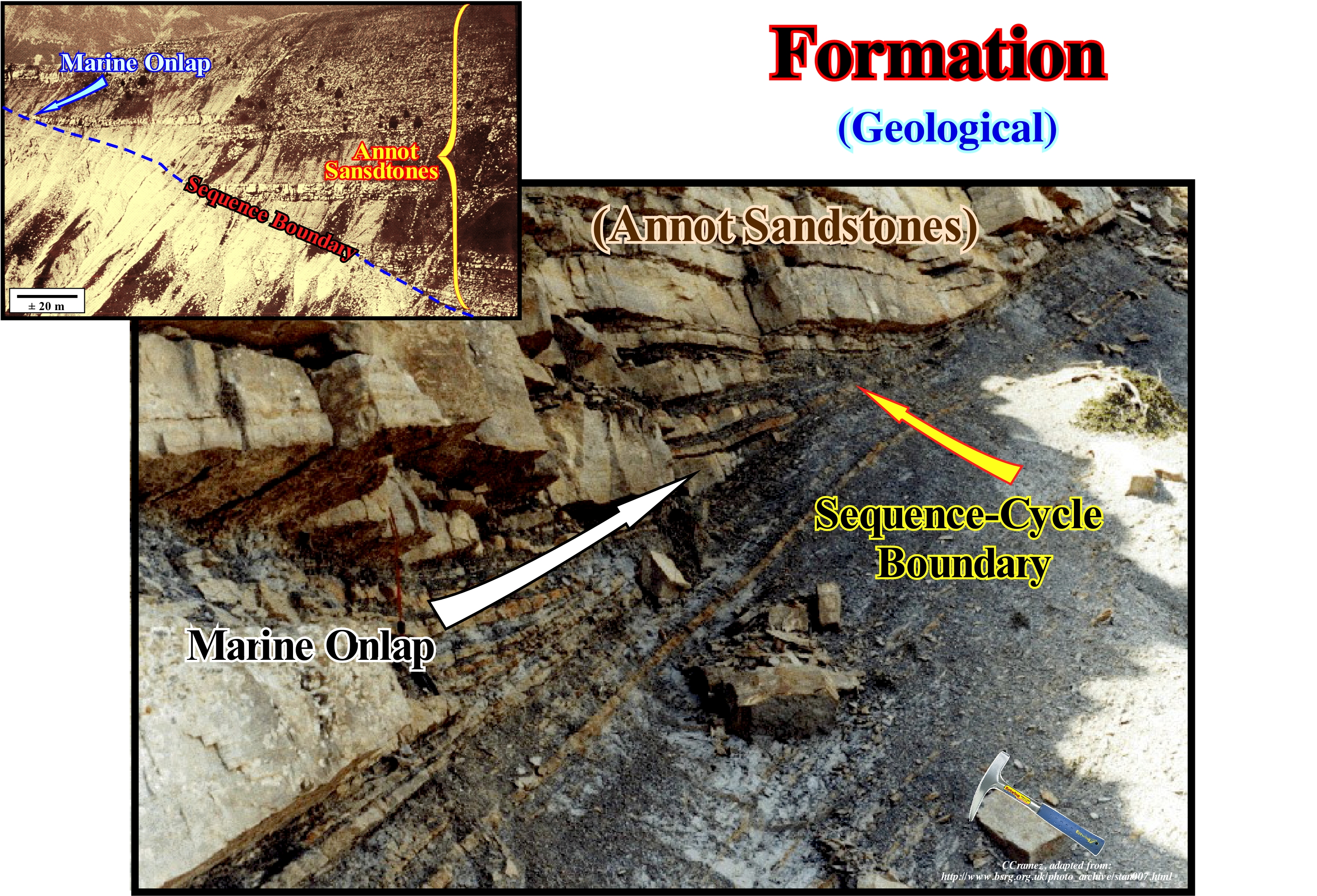
A geological formation or simply a formation is the fundamental unit of lithostratigraphy. A formation consists of a number of strata having a lithology, facies or other comparable properties. The thickness of the different formations can vary widely. The concept of strata, formally, defined is fundamental in stratigraphy. Formations are, often, divided in groups. Recognition of formations allows geoscientists to correlate strata across large distances between rocky outcrops. The formations were, initially, described as geological time markers based on relative ages and on the superposition law. Geological formations may also be metamorphic rocks and volcanic flows. The igneous intrusive rocks are, generally, not divided into formations. Formations are the just lithostratigraphic units in which the stratigraphic column must be, completely, divided by lithology. Formations should be able to be delineated to the scale of the geological mapping practiced in the region. Geological formations are designated, typically, by the name of the geographical area in which they were first described. Strictly speaking, formations can not be defined by any other criterion, other than lithology. Formation is also used, informally, to describe the sometimes strange shapes that rocks acquire through depositional processes. With the advent of sequential stratigraphy and the access of the academies at the seismic data of oil companies, the analysis of lithostratigraphic units is less and less used (except in field studies, which are practically all, more or less, done). Sequential stratigraphy is based, mainly, on the analysis of chronostratigraphic units induced, mainly, by eustasy (changes of absolute or eustatic sea level that is supposed global and referenced to the Earth's centre), gives more satisfactory results and allows to make predictions more difficult to refute than those made from lithostratigraphy. A lithostratigraphic unit always has the same lithology. A chronostratigraphic unit (same time) has different lithologies. Different depositional systems exist along the same chronostratigraphic line (depositional surface). In this photograph, is illustrated the geological Annot sandstones formation*. It is formed by set of strata (sands and clayey rocks) deposited in deep-water. The strata terminate against a stratigraphic cycle boundary that clearly correlates upstream with an unconformity** that corresponds to an area defined by marine onlaps of the overlying sediments and by toplaps of the underlying sediments. They emphasize the deposition of the submarine basin floor fans (SBFF) that characterize the geological formation of Annot sandstones. They were deposited during relative sea level falls that created appropriate geological conditions for the trigger of turbidite currents which transported along the continental slope, the sedimentary particles that the rivers dumped on the continental slope. The sedimentary particles transported to the lower parts of the basin deposited since gravity currents decelerate and lose much of their carrying capacity. The clay levels between the turbiditic sandstones are, mainly, pelagic shales. The fossils of these shales characterize depositional deep environment and they give, more or less, the age of the turbiditic layers. Turbidite layers, composed by sedimentary particles transported, mainly, from the coastal plain, are deposited almost instantaneously, while the pelagic shale have a depositional time of thousands of years.
(*) These sandy turbidite formations, at present-time at around 1,000 meters of altitude. with more than 1,000 meters of thickness, were deposited before the translation of the block Corsica/Sardinia. In the Middle Oligocene, the Alps were formed inducing the appearance of the Mediterranean. At the end of the last glaciation, the cliffs, weakened by the melting of the ice, release large blocks that slide on marls. However, over time, the forest was developed stabilizing the sandstone blocks that have remained, more or less, stable over the last millennia.
(**) Erosional surface induced by a significant decline in relative sea level, which exhumed the continental shelf and the upper slope of the continental slope)
Formation Water............................................................................................................................................................................Eau de formation
Água de formação / Agua de formación / Formation Wasser / 地层水 / Пластовая вода / Acqua di formazione /
Water stored in the pores of a rock, in general, sedimentary that has not been in contact with the atmosphere for a long time (geological time). Formation water or interstitial water is not necessarily the water that was present when the rock was deposited, i.e., it is not necessarily a fossil water.
See: « Reservoir-Rock »
&
« Trap (oil or gas) »
&
« Juvenile Water »

When a rock-reservoir* with water (there are reservoir-rocks, just with hydrocarbons) has the maximum saturation (percentage of porosity occupied by a fluid) in hydrocarbons, the formation water, which occupies the rest of the porosity is the reducible saturation water. In this sketch of a rock-reservoir with water and oil, the irreducible saturation, which by definition is water, represents the film of the adsorbed water**, i.e., of the water coating the more or less continuous surfaces of the grains quartz and the water around the grain contacts and in the pore strangulations. The irreducible saturation water corresponds to a stable situation. It differs from the residual saturation water, which can be determined by analysing the probe cores. The difference between irreducible and residual water saturation is due to the invasion of the filtrate (drilling mud) and expansion of the associated gas that occurs when the sample is withdrawn from the well to the surface. The irreducible saturation of any fluid is the minimum saturation that the fluid can achieve when it is displaced in a porous medium by another fluid that is not miscible with the former. A rock-reservoir can have different wettabilities. Wettability is the property of a, more or less, continuous surface being wetted in contact with a liquid, i.e. when the surface tension*** of the liquid is reduced so that the liquid spreads on the surface. In most reservoir-rocks, water represents the wet phase (adhesive film on the grains), but in certain reservoir-rocks, the oil may also constitute the wet phase. During primary oil production, only about 25% of the total oil is recovered. At the end of secondary production (assisted production), about 50% of the oil remains in the reservoir. The same happens in the water wells. Primary oil production depends just on natural processes: (i) Displacement of oil by water ; (ii) Expansion of the natural gas in the upper part of the reservoir ; (iii) Expansion of the gas, initially, dissolved in crude oil ; and (iv) Gravity drainage resulting from the oil circulation at the top of the reservoir to the lower parts where the wells are located. In an assisted oil production which is, generally, used after primary production, since pressure is not sufficient to cause the oil to rise to the surface, different methods can be used to increase rock-reservoir pressure: (i) Injection of water ; (ii) Re-injection of natural ; (iii) Lift gas (injection of compressed air, carbon dioxide or any other gas to raise the oil by lowering the hydrostatic pressure inside the well). Suction pumps (horse head pumps, which are the surface part of piston impeller pumps installed in oil wells) and submersible electric pumps are widely used in assisted production. Among the tertiary recovery oil recovery methods, which increase the mobility of oil and thus its rate of extraction, thermal methods are the most common. The oil is heated which reduces its viscosity, significantly, and facilitates its extraction. Steam injection, which is the most frequent thermal method, is almost always done from a co-generation plant (process of simultaneous generation of electricity and heat from energy from the same source).
(*) A rock-reservoir is a rock to which oil can migrate and where it can, eventually, be detained if the rock-reservoir is part of an oil trap. Sandstones, which may have significant porosity, are probably the most common reservoir-rocks. Limestones and dolomites, some of which are formed by remains of skeletons from ancient coral reefs are also examples of reservoir-rocks.
(**) Adsorption is the adhesion of molecules of gas, ions or molecules in solution to the surfaces of the solids with which they are in contact.
(***) Surface tension is a physical effect occurring at the interface between two chemical phases (portions of matter that have different properties, which may be continuous or fragmented into several parts), which causes the surface layer of a liquid to behave as an elastic membrane. The surface tension is caused by the cohesive forces between similar molecules whose vector result is different at the interface. While molecules within a liquid are drawn in all directions by the neighbouring molecules, the molecules on the surface of the liquid undergo only lateral and internal attractions. This unbalance of the forces of attraction causes the interface to behave like an elastic film (https://pt.wikipedia.org/wiki/Tens%C3%5Superficial).
Fossil..................................................................................................................................................................................................................................................................Fossile
Fássil / Fósil / Fossil / 化石 / Ископаемое (окаменелость) / Fossile /
Trace or evidence of past life, such as bones, shells, molds, prints or trails.
See: « Relative Age »
&
« Index Fossil »
&
« Geological Time »

All geoscientists knows, fossils are traces or remains of animals or plants, or other organisms, that occupied the Earth's surface. Trilobites are, certainly, the fossils through which the great majority of geology students have discovered Paleontology. The trilobites, as, for example, the one illustrated in this figure (Conocoryphe Sulzeri Soundbooth), are perhaps after the Dinosaurs, the best-known fossils of the general public. Trilobites are arthropods (invertebrate animals with articulated appendages, segmented bodies and rigid skeletons) forming the class Trilobita class. There are more than 1500 genera and more than 17,000 species of trilobites. They appeared in the Early Cambrian and developed throughout the Lower Paleozoic before they began a long decline. They were extinguished during Devonian Late (exception made to the trilobites of the order Proetida, that disappeared at the end of the Devonian). It may be said all trilobites disappeared in association as what geoscientists call the Permian extinction that occurred some 250 million years ago. The size of the trilobites ranges from 1 mm to almost 1 meter (72 cm for the largest trilobite found in the world till today Isotelus rex). The outer skeleton of a trilobite consisted mainly of minerals, based on calcium phosphate, dispersed in a chitin matrix. From bottom to top, the skeleton could be divided into three parts (as illustrated above): (i) Cephalon, composed of two pre-oral segments and one post-oral, resulting from the fusion of four elements ; (ii) Thorax, composed of articulated segments, which allowed the animal to be rolled up to protect itself from predators ; and (iii) Pygidium composed of the last segments that normally are amalgamated with telson (fin at the abdomen). Laterally, three elements are always well visible: (a) Axial Lobe ; (b) Left Pleural Lobe and (c) Right Pleural Lobe. Most of the trilobites lived on the sea floor of the continental shelves. The tracks left by displacement of the trilobites, which are often very well preserved, are the Cruzianas.
Fossil Fuel...................................................................................................................................................................................................Combustible fossile
Combustível fóssil / Combustible fósil / Fossile Brennstoffe / 化石燃料 / Горючее ископаемое / Combustibili fossili /
Geological fuel (hydrocarbons) of biological origin such as coal, oil, natural gas, bituminous clay, asphaltic sands, etc.
See: « Petroleum »
&
« Coal »
&
« Gas »
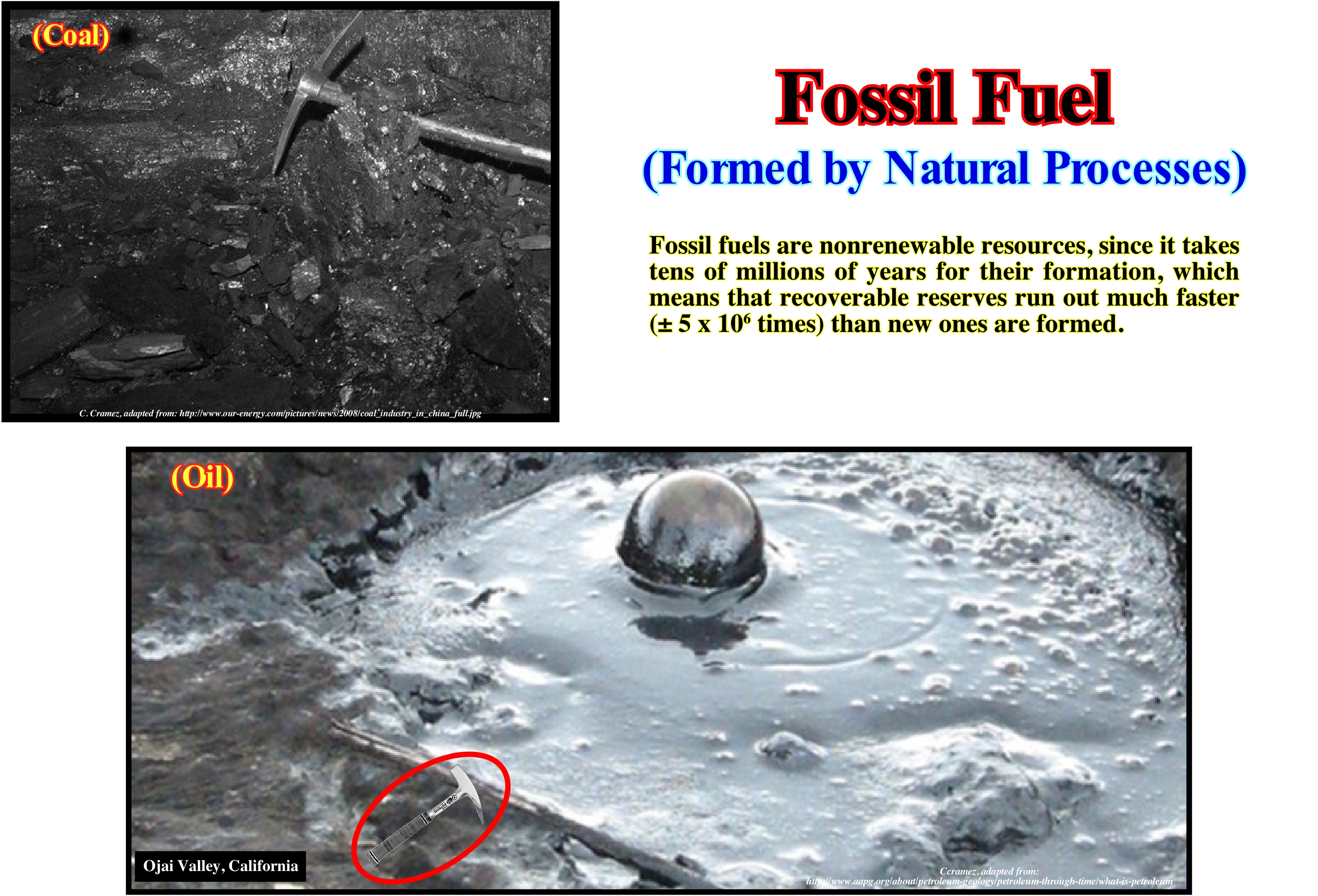
The main fossil fuels are coal, oil and gas. Coal is a very combustible rock, containing more than 50% by weight and more than 70% by volume of organic material, including mixtures formed by compaction * and induration of the altered plant remains, similar to those found today in the peat bogs **. Petroleum, which most people call oil, is a liquid substance viscous at room temperature and is not only hydrophobic (not mixed with water), but also lipophilic, that is to say, it mixes with other oils. Petroleum, like all other oils, is very rich in carbon, hydrogen and is of organic origin. Most of the time, petroleum is found in the pores of sedimentary rocks (reservoir-rocks), particularly when these are folded and covered by impermeable rocks (sealing-rocks). Gas, which is often referred to as natural gas (although it is as natural as petroleum), is a gaseous fossil fuel composed primarily of methane (CH4), but contains in general significant amounts of ethane (C2 H6), propane(C3 H8), butane (C4 H10) and pentane (C5H12). These accessory gases such as carbon dioxide, nitrogen, helium and hydrogen sulphide which are coupled in small amounts are removed before the gas is used as fuel. Natural gas is often associated with oil (associated gas) or isolated (non-associated gas). The gas is also associated with the layers of coal. Gases rich in methane (biogas or natural biogas) are produced by the decomposition of organic matter (biomass). Petroleum and natural gas are mainly produced in sedimentary rocks rich in organic matter (source-rocks). But for this it is necessary that the potential source-rock (which can generate oil) is, sufficiently, buried so that its organic matter matures. In depth the organic matter evolves passing, in general, by three very distinct zones: (i) Humid gas zone; (ii) Oil zone and (iii) Dry gas zone.
(*) Volume reduction or sediment thickness, usually fine grain, due to increased sediment load or tectonic pressures.
(**) Peat bogs refer to vegetation in marshy areas, more or less, horizontal or slightly sloping, in which the plants are alive at the top and dead at depth, and which create a mediocre spongy fuel called peat, which can accumulate in layers thick.
Fourier Analysis..........................................................................................................................................................................Analyse de Fourier
Análise de Fourier / Análisis de Fourier / Fourier-Analyse / 傅立叶分析 / анализ Фурье / Analisi di Fourier /
Transformation of complex functions by the sum of simple trigonometric functions. A Fourier transform is the process of decomposing a given function into basic functions. This process creates another function that describes how much each basic function is fundamental in the original function. In the processing of the seismic signals, Fourier analysis isolates the components of the complex wave fronts by concentrating them to facilitate their detection and/or removal.
See: « Seismic Line »
&
« Wave »
&
« Reflection Seismic »

Fourier's analysis, or Fourier's series, is based on the principle of interference. The combination of two or more waves forms a composite wave (resulting). There are two types of interference: (i) Constructive interference and (ii) Destructive interference. The waves interference obeys the principle of superposition, which says the displacements of two or more interfering waves can be added, algebraically, to produce the resulting wave. Fourier analysis applies to the study of complex forms such as the deformation of the Earth's surface by an earthquake, the shape of a comet's orbit, the gravitational action of several planets or the flow of heat through an insulating plate, etc. Fourier has shown such shapes (such as the upper curve shown in this figure) can be represented by the sum of simple waves. The equations describing single waves can be added to solve the complex shapes. In the example illustrated above, the curve 1 can be represented by the sum of curves a, b and c. The solutions of each of these simple curves can be added to solve curve 1. Mathematically, the Fourier's series or analysis is the way to express a function as the sum of sines* and harmonic cosines (Fourier analysis was known as harmonic analysis **). In other words, the Fourier series correspond to the development of a periodic function {f (x)} in terms of an infinite sum of sine and cosine, using orthogonal relations between these two functions. Until the advent of computers Fourier analysis (series) was, by far, the best weapon in the scientific arsenal to solve the complexity of nature. In fact, all the great scientific discoveries of the nineteenth century were based on techniques that were initiated by Fourier.
(*) One of the best ways to recall what is the sine, cosine, and tangent of an angle φ is to consider a point on a circle of radius r and the horizontal and vertical axes passing through the centre of the circle as Cartesian coordinates. The point x on the horizontal axis that is, generally, known is the variable y the point y on the vertical axis which, in general depends on the point x, is the function (the opposite is also possible). Thus any point 'P' located in the circle can be characterized by the coordinates x and y. The x-coordinate is the cosine of the angle φ defined by the radius «r» of the circle passing through P and the horizontal axis (x-axis), while the y-coordinate is the sine of the same angle φ. In fact, x, y and the radius r define a right triangle in which x and y are the hinges and r is the hypotenuse, which means that if the radius of the circle is equal to 1, according to the Pythagorean theorem (sin φ)2+ (cos φ)2 =1. If the point P is moved in the opposite direction of the hands of a clock, it is easy to see that sin φ (i.e. the y coordinate) will vary from 0 (φ = 0) to 1 (φ = 90 °), then to 1 for 0 (φ = 180 °) and then to -1 (φ = 270°) and again to 0 after a full rotation (φ = 360°). Obviously, the same is true for the cosine of φ which varies from 1 to 0, -1, 0 for the end of a turn again to 1 (φ = 0). The tangent of φ (tan φ) emphasizes the slope of the radius passing through the point P and is given by the ratio sin φ / cos φ, which means that when φ = 45 ° the tangent equals 1, since sin φ = cos φ and that for φ = 90 ° (vertical radius) the tangent equals infinity, since tan 90° = sin 90° / cos 90° = 1/0 = infinity.
(**) A harmonic analysis can be analyzed as the projection of the circular motion of a point on an axis (see (*) definition of the sine and the cosine of an angle).
Fourth Order Eustatic Cycle...................................................................................Cycle eustatique de 4ème ordre
Ciclo eustático de 4a ordem / Ciclo eustático de 4° orden / Vierte Ordnung eustatischen Zyklus / 四阶海平面周期 / Эвстатический цикл четвертого порядка / Ciclo eustatiche (4°ordine) /
Eustatic cycle with a duration between 0.1 and 0.5 My (millions of years).
See: « Eustatic Cycle »
&
« Supercontinent »
&
« Stratigraphic Cycle »

Within a 3rd order eustatic cycle, smaller eustatic cycles of shorter duration, may be recognized, as for instance, 4th order cycles whose time-duration ranges from 100 ky to 500 ky (thousands of years). In a 3rd or 4th order eustatic cycle, sea level changes are not continuous. When the relative sea level* rises, it can start by rising 2 meters, stabilizing, rising again 4 m and stabilizing or falling a little, then rising 6 meters and then descending. That gives total relative sea level rise of 13 meters in acceleration. The relative sea level may also increase in deceleration, for example: (i) Rising 6 m ; (ii) Stability ; (iii) Rising 4 m ; (iv) Stability ; (v) Rising 3 m ; (vi) Stability ; (vii) Rising 1 meter ; (viii) Falling. That gives a total relative sea level rise of 14 meters in deceleration. On the other hand, the relative sea level can vary as follows: (a) Rising 3 m ; (b) Falling 1 m ; (c) Rise 5 m , (d) Falling 2 m ; (e) Rising 10 m ; (f) Falling 4 m; (g) Rise 15 m ; (h) Falling 7 m, etc. In this case, one can also speak of a relative sea level rise of 19 meters. However, such a relative sea level rise is not due to eustatic paracycles, i.e., by marine ingressions without relative sea-level falls, as before, but by a set of eustatic cycles. The marine ingressions are limited by erosional surfaces, i.e., by unconformities and not by flooding surfaces. There is any relative sea level fall between eustatic paracycles, just a stability period of relative sea level. It is during these stable periods of the relative sea level that deposition occurs. One or more sedimentary progradational systems tracts, that shift the shoreline seaward, can be deposited. In the other words, a marine ingression, which displaces the shoreline continentward, creates a small ravinment surface in the pre-existing topography, is always followed by a sedimentary regression, deposited during the stability period of relative sea level, which moves the shoreline seaward. When the time-duration of the relative sea level falls and rises is between 100 ky and 500 ky, they correspond to 4th order eustatic cycles. The high frequency cycles (4th and 5th order) are associated with the climatic changes created by the Milankovitch orbital cycles, whose periodicities are: (a) 100 ky, between 0 and 800 ka ; (b) 800 k and between 0.8 Ma and 6.3 Ma ; (c) 1.6 My, between 6.3 Ma and 150.5 Ma ; (d) 4.0 My, between 150.5 Ma and 177.0 Ma ; (e) 1.6 M, between 177.0 Ma and 188.5 Ma ; (f) 4.0 My, between 188.5 Ma and 237.0 Ma and (g) 1.6 My, between 237.0 Ma and the Permian base. On the seismic lines, the stratigraphic cycles induced by the 4th order eustatic cycles are just recognized in depositional depocenters with high sedimentation rates, such as in Mississippi (Gulf of Mexico) or in Mahakam (Indonesia, offshore East of Borneo) delta buildings. However, even in these particular cases, stratigraphic cycles are difficult to recognize and are, rarely, complete. Certain sub-groups of sedimentary systems tracts do are not present. When the stratigraphic cycles associated with the 3rd order eustatic cycles, that is, when the sequence-cycles are complete, they are formed by two groups of systems tracts: (i) Lowstand systems tracts group (LSTG), in which are three sub-groups, which from bottom to top are: a) Submarine Basin Floor Fans (SBFF) : b) Submarine Slope Fans (SSF) and c) Lowstand Prograding Wedge (LPW) ; (ii) Highstand systems tracts group (HSTG), in which there are two sub-groups: a) Transgressive Interval (TI) and b) Highstand Prograding Wedge (HPW). Each of the systems tracts sub-groups may be formed by an unique systems tract (lateral association of synchronous and genetically linked deposition systems) or by a set of systems tracts. Generally, in the stratigraphic cycles associated with the 4th order eustatic cycles, the highstand prograding wedge (HPW) is almost always absent, and often the transgressive interval (TI) as well. Some geoscientists think that sequence-paracycles (parasequences of Exxon's geoscientists) are associated with 4th order eustatic cycles. We prefer to associate them with eustatic paracycles, which are not cycles, since between each relative sea level rise , the relative sea level is stabilized (it does not fall), hence the prefix para-.
(*) Relative sea level and sea level relative are synonymous, however it seems more correct to say relative sea level. Both expressions refer to the sea level measured relatively to a local point on the Earth's surface, that may be the sea floor or the top of the continental crust,i.e, the base of the sediments. Relative sea level is the result of the combined action of tectonics (subsidence or uplift of the sea floor) and the absolute (eustatic) sea level, which is supposed to be global and referenced to the Earth's centre.
Fragipan............................................................................................................................................................................................................................................Fragipan
Fragipan / Fragipan / Fragipan (Soil Taxonomy) / Fragipan(土壤分类学) / Уплотнённый внутрипочвенный горизонт / Fragipan (tassonomia del suolo) /
Dense soil layer, composed of fine sand, without organic matter and with very little clay material, which is, relatively, little permeable to water, mainly, due to its hardness and compaction rather than to its content in clay or to its cementation .
See: « Sand »
&
« Compaction »
&
« Organic Matter (types) »

This photograph illustrates a fragipan horizon south of Pier, near Julich in North Rhine-Westphalia (Germany). The origin of the fragipan, is much discussed. Geoscientists, who deal with the study of soils (pedology), discuss not only the definition of fragipan, but also whether or not it exists in certain landscapes. Its formation can be attributed to the following factors: (i) Compaction of the soils by the glaciers of the last glaciation ; (ii) Physical maturation ; (iii) Permafrost processes (processes occurring in a soil when the temperature is below 0 ° C for at least two years) or (iv) Other events occurring during the Pleistocene. Some fragipan inherited their properties from buried soils (paleosols). According to American soil terminology, a fragipan must meet the following conditions: (a) Have a thickness of at least 15 cm ; (b) Show evidence of pedogenesis (soil formation process), either inside or on surfaces that limit the range considered ; (c) Have a prismatic, columnar, or cylindrical architecture and without well-marked structures, that is, it must be more or less massive ; (d) Allow root penetration, with a spacing of about 10 cm, along fractures ; (e) Fragments larger than 5-10 cm in diameter (when dry) should represent more than 50% of the volume of the range (when submerged in water) ; (f) Have at least 60% or more of sturdy, practically, rootless material ; (g) Do not be effervescent in dilute hydrochloric acid. All this means a fragipan must have a certain thickness resulting from the alteration of an older sedimentary material. It does not result from a change caused by the roots that penetrate it, along fractures. It is very hard even when moist and does not contain calcium or magnesium carbonate. Do not confuse fragipan with duripan which is a soil horizon that has been cemented by illuvial silica (displaced from another level by rain-water).
Fresnel Zone.....................................................................................................................................................................................................Zone de Fresnel
Zona de Fresnel / Zona de Fresnel / Fresnel-Zone / 菲涅尔区 / Зона Френеля (промежуточная зона) / Zona di Fresnel /
Horizontal dimension of the seismic resolution. The reflected seismic waves interfere, constructively, where their trajectory differs from less than half a wave-length, and the portion of the reflecting surface surrounding these reflections is the first Fresnel zone.
See: « Reflection Coefficient »
&
« Common Depth Point (seismic) »
&
« Reflection Seismic »
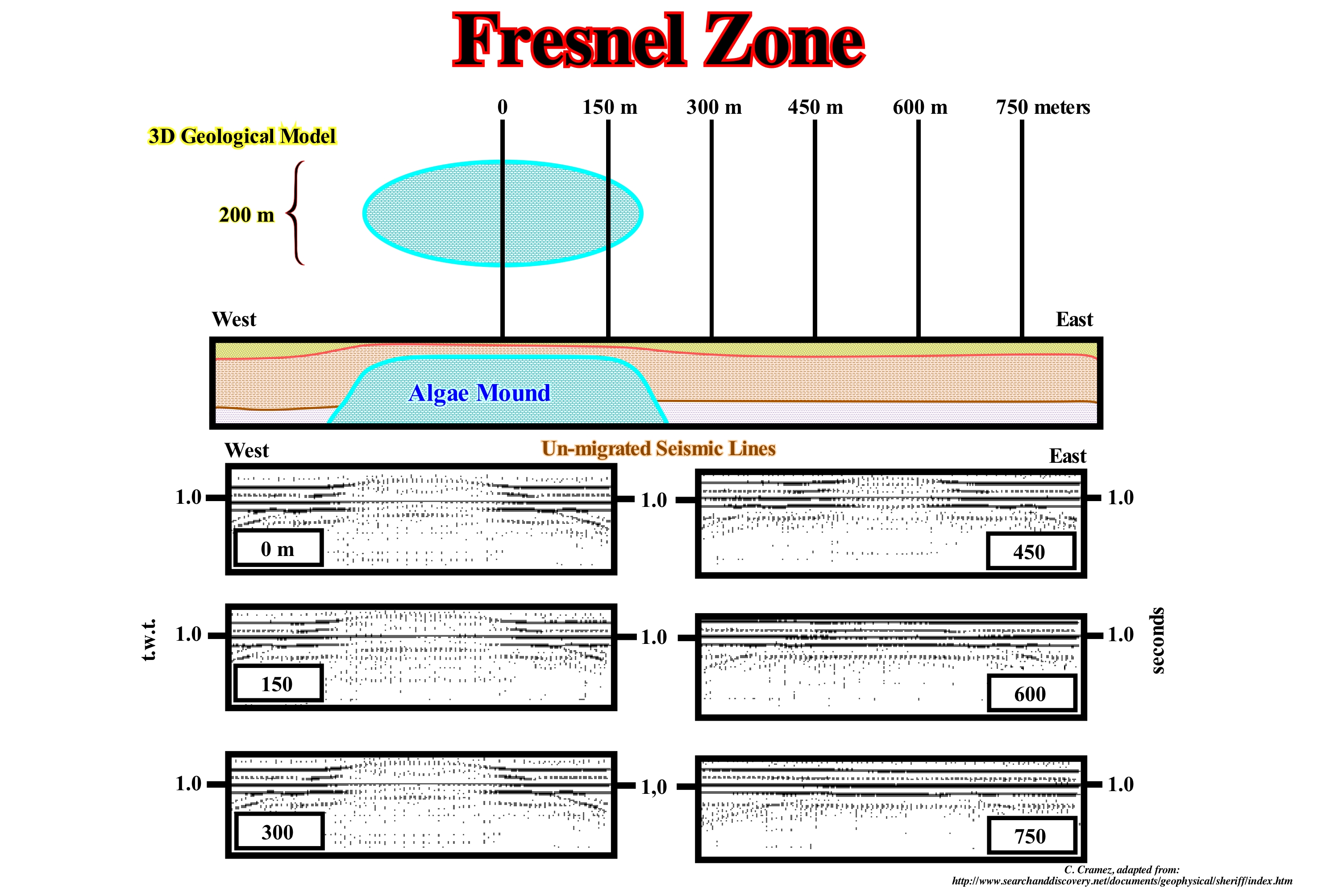
The reflected waves of an interface interfere constructively when their paths differ by at least half wave-length and the area of the reflecting interface is the first Fresnel zone. Outside the boundaries of the first Fresnel zone, the interference will be, alternatively, constructive and destructive. Fresnel showed that the destructive contribution of some of these zones, outside the first zone of Fresnel, is displaced by the constructive contribution of other zones. The reaction of the reflector responsible for the reflection will be just that of the first Fresnel zone. In other words, the reflection which is supposed to return to the surface from a point is, actually, reflected by an area having the dimensions of the first Fresnel zone. The adjective "first" is often not used by the great majority of the geoscientists, who simply say Fresnel zone. The dimensions of the Fresnel zone can be calculated geometrically. The radius of the Fresnel zone depends on the wavelength, which is a function of frequency and velocity. In order to interpret the changes in acoustic impedance, porosity, saturation in hydrocarbons, lithology, porosity-thickness, etc., the entire surface affected by the migration process must be integrated in order to obtain the correct relative value. For example, in an oilfield, if the porosity-thickness of a 3D seismic campaign is to be, correctly, computed, the campaign must cover the entire Fresnel area, even outside the accumulation. On the other hand, as illustrated in this figure, in the 2D profiles, due to the data leaving the plane, the mound of algae is observed in all profiles that are inside a window of 300 meters, which exceeds the dimensions of the mound. A profile at 250 meters is similar to the profile that passes through the centre of the mound. That is why the whole seismic campaign must extend beyond the area on which one intends to interpret the changes of amplitude of a distance equal to that which is required by the migration process.
Fringing Reef (Onshore reef)..............................................................................................................................Récif frangeant (Récif côtier)
Recife costeiro / Arrecife en franja, costero / Franzenriff, Küstenriff / 边礁 / Окаймляющий или береговой риф / Fringing scogliera, Frange reef (barriera corallina) /
That develops supported to the rocks of the platform, in bands, more or less, parallel to the shoreline. Between a coastal reef and the coast there is a narrow, shallow channel that certain geoscientists call a boat channel. Synonym of Reef flat or Reef slope.
See: «Reef»

